|
|
|||||||||||||||||
| Point ID: 9511 | Downloads | Plots | Site Data | Code: 15281000 |
|
|
|||||||||||||||||
| Download | |
|---|---|
| Site Descriptor Information | Site Time Series Data |
| Link to all available data | |
| View: | Time Series | All |
| Units: | m3/s |
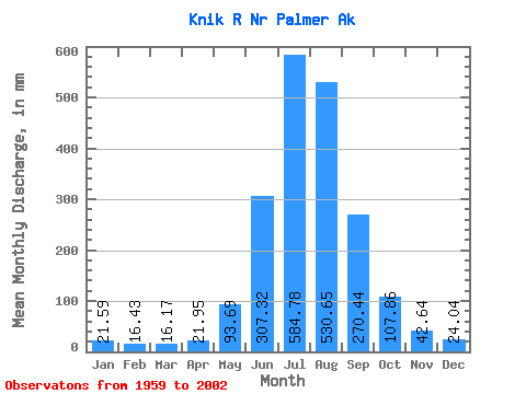
| Statistic | Jan | Feb | Mar | Apr | May | Jun | Jul | Aug | Sep | Oct | Nov | Dec | Annual |
|---|---|---|---|---|---|---|---|---|---|---|---|---|---|
| Mean | 21.59 | 16.57 | 16.17 | 21.95 | 93.68 | 307.32 | 584.69 | 530.57 | 270.44 | 107.84 | 42.64 | 24.04 | 2004.68 |
| Standard Deviation | 15.71 | 9.78 | 6.89 | 7.85 | 41.06 | 93.93 | 100.01 | 85.69 | 65.67 | 42.34 | 22.02 | 8.04 | 204.08 |
| Min | 11.41 | 7.65 | 6.45 | 8.36 | 25.79 | 62.39 | 432.62 | 378.67 | 158.35 | 44.22 | 15.29 | 12.41 | 1536.29 |
| Max | 93.81 | 55.70 | 32.60 | 36.84 | 182.29 | 479.28 | 929.33 | 702.20 | 407.35 | 233.70 | 116.34 | 47.94 | 2390.97 |
| Coefficient of Variation | 0.73 | 0.59 | 0.43 | 0.36 | 0.44 | 0.31 | 0.17 | 0.16 | 0.24 | 0.39 | 0.52 | 0.33 | 0.10 |
 Return to R-Arctic Net Home Page