|
|
|||||||||||||||||
| Point ID: 9511 | Downloads | Plots | Site Data | Code: 15281000 |
|
|
|||||||||||||||||
| Download | |
|---|---|
| Site Descriptor Information | Site Time Series Data |
| Link to all available data | |
| View: | Time Series | All |
| Units: | mm |
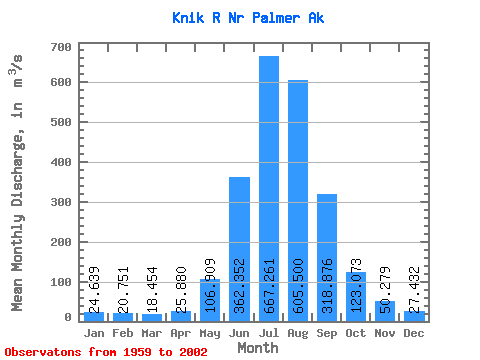
| Statistic | Jan | Feb | Mar | Apr | May | Jun | Jul | Aug | Sep | Oct | Nov | Dec | Annual |
|---|---|---|---|---|---|---|---|---|---|---|---|---|---|
| Mean | 24.64 | 20.75 | 18.45 | 25.88 | 106.91 | 362.35 | 667.26 | 605.50 | 318.88 | 123.07 | 50.28 | 27.43 | 194.13 |
| Standard Deviation | 17.92 | 12.24 | 7.87 | 9.25 | 46.86 | 110.75 | 114.14 | 97.79 | 77.44 | 48.32 | 25.97 | 9.17 | 19.76 |
| Min | 13.02 | 9.58 | 7.36 | 9.85 | 29.43 | 73.57 | 493.72 | 432.15 | 186.71 | 50.46 | 18.03 | 14.16 | 148.77 |
| Max | 107.06 | 69.77 | 37.20 | 43.44 | 208.04 | 565.11 | 1060.57 | 801.37 | 480.30 | 266.71 | 137.18 | 54.72 | 231.54 |
| Coefficient of Variation | 0.73 | 0.59 | 0.43 | 0.36 | 0.44 | 0.31 | 0.17 | 0.16 | 0.24 | 0.39 | 0.52 | 0.33 | 0.10 |
 Return to R-Arctic Net Home Page