|
|
|||||||||||||||||
| Point ID: 9511 | Downloads | Plots | Site Data | Code: 15281000 |
|
|
|||||||||||||||||
| Download | |
|---|---|
| Site Descriptor Information | Site Time Series Data |
| Link to all available data | |
|
|
| View: | Statistics | Time Series |
| Units: | m3/s |
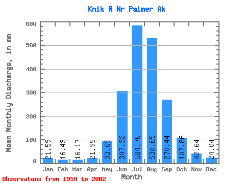
| Statistic | Jan | Feb | Mar | Apr | May | Jun | Jul | Aug | Sep | Oct | Nov | Dec | Annual |
|---|---|---|---|---|---|---|---|---|---|---|---|---|---|
| Mean | 21.59 | 16.57 | 16.17 | 21.95 | 93.68 | 307.32 | 584.69 | 530.57 | 270.44 | 107.84 | 42.64 | 24.04 | 2004.68 |
| Standard Deviation | 15.71 | 9.78 | 6.89 | 7.85 | 41.06 | 93.93 | 100.01 | 85.69 | 65.67 | 42.34 | 22.02 | 8.04 | 204.08 |
| Min | 11.41 | 7.65 | 6.45 | 8.36 | 25.79 | 62.39 | 432.62 | 378.67 | 158.35 | 44.22 | 15.29 | 12.41 | 1536.29 |
| Max | 93.81 | 55.70 | 32.60 | 36.84 | 182.29 | 479.28 | 929.33 | 702.20 | 407.35 | 233.70 | 116.34 | 47.94 | 2390.97 |
| Coefficient of Variation | 0.73 | 0.59 | 0.43 | 0.36 | 0.44 | 0.31 | 0.17 | 0.16 | 0.24 | 0.39 | 0.52 | 0.33 | 0.10 |
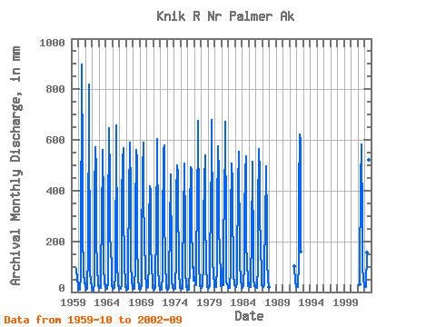
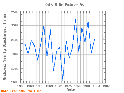
| Year | Jan | Feb | Mar | Apr | May | Jun | Jul | Aug | Sep | Oct | Nov | Dec | Annual | 1959 | 94.84 | 53.03 | 24.27 | 1960 | 13.09 | 8.16 | 8.21 | 13.37 | 63.27 | 129.60 | 929.33 | 518.59 | 238.13 | 79.26 | 32.43 | 36.67 | 2047.27 | 1961 | 34.76 | 31.14 | 8.89 | 13.57 | 46.92 | 118.16 | 844.69 | 535.55 | 281.54 | 82.02 | 39.82 | 21.61 | 2039.52 | 1962 | 15.06 | 7.65 | 6.45 | 9.70 | 30.43 | 379.03 | 589.02 | 499.46 | 232.67 | 77.06 | 50.59 | 23.45 | 1908.77 | 1963 | 16.29 | 16.04 | 19.31 | 16.09 | 102.61 | 273.41 | 569.25 | 579.18 | 345.81 | 105.99 | 30.79 | 29.70 | 2089.99 | 1964 | 20.77 | 12.15 | 11.77 | 28.27 | 28.01 | 278.99 | 668.18 | 452.39 | 236.90 | 157.91 | 116.34 | 24.91 | 2022.79 | 1965 | 15.64 | 15.18 | 13.38 | 15.80 | 25.79 | 62.39 | 678.68 | 431.66 | 406.09 | 125.36 | 29.80 | 14.15 | 1819.26 | 1966 | 11.77 | 10.17 | 11.17 | 11.18 | 28.88 | 367.92 | 540.12 | 587.66 | 328.22 | 118.62 | 24.98 | 19.53 | 2048.12 | 1967 | 15.77 | 10.68 | 9.94 | 12.17 | 105.49 | 399.30 | 583.18 | 609.75 | 390.51 | 115.78 | 42.19 | 18.76 | 2300.58 | 1968 | 14.02 | 11.62 | 12.15 | 16.73 | 110.32 | 298.22 | 581.26 | 540.60 | 203.19 | 56.95 | 15.29 | 12.81 | 1858.07 | 1969 | 11.91 | 10.85 | 12.97 | 25.18 | 179.21 | 479.28 | 608.07 | 378.67 | 219.83 | 233.70 | 58.12 | 37.94 | 2241.83 | 1970 | 21.33 | 15.92 | 18.98 | 21.64 | 111.49 | 273.09 | 432.62 | 407.73 | 213.26 | 79.88 | 62.12 | 18.49 | 1666.60 | 1971 | 12.74 | 10.40 | 11.08 | 14.77 | 42.82 | 252.73 | 599.91 | 622.88 | 242.28 | 106.21 | 28.06 | 16.85 | 1944.10 | 1972 | 12.53 | 9.46 | 9.32 | 8.36 | 70.25 | 241.85 | 577.74 | 596.54 | 323.25 | 105.17 | 42.59 | 17.61 | 1999.53 | 1973 | 11.65 | 8.20 | 7.80 | 19.05 | 83.30 | 241.58 | 479.93 | 437.26 | 179.02 | 51.79 | 16.41 | 12.41 | 1536.29 | 1974 | 12.41 | 11.30 | 12.41 | 22.93 | 127.65 | 385.69 | 516.42 | 480.34 | 407.35 | 66.63 | 35.03 | 17.05 | 2086.48 | 1975 | 14.77 | 10.70 | 11.69 | 12.65 | 98.11 | 289.16 | 524.27 | 488.65 | 285.20 | 89.97 | 19.93 | 13.37 | 1845.94 | 1976 | 11.41 | 9.43 | 9.59 | 22.94 | 88.41 | 320.77 | 509.78 | 494.25 | 287.18 | 97.47 | 98.59 | 47.94 | 1986.63 | 1977 | 44.98 | 55.70 | 32.60 | 28.59 | 103.57 | 380.11 | 600.87 | 697.00 | 296.81 | 118.67 | 28.43 | 17.49 | 2390.97 | 1978 | 16.01 | 16.15 | 23.97 | 35.02 | 103.54 | 290.95 | 445.59 | 557.88 | 294.88 | 112.31 | 25.72 | 20.03 | 1929.86 | 1979 | 14.31 | 11.98 | 15.91 | 27.90 | 147.70 | 325.33 | 560.85 | 702.20 | 263.69 | 124.13 | 70.22 | 31.19 | 2277.81 | 1980 | 19.54 | 18.25 | 20.71 | 28.12 | 98.80 | 321.39 | 593.98 | 478.16 | 247.95 | 166.89 | 56.35 | 24.25 | 2060.26 | 1981 | 93.81 | 34.95 | 29.61 | 25.23 | 182.29 | 391.86 | 589.26 | 693.07 | 246.88 | 44.22 | 30.10 | 23.65 | 2368.15 | 1982 | 16.73 | 17.00 | 17.89 | 27.09 | 83.65 | 297.63 | 524.43 | 441.99 | 372.13 | 67.91 | 30.82 | 28.57 | 1916.65 | 1983 | 26.29 | 23.01 | 20.90 | 36.84 | 104.63 | 420.52 | 573.65 | 515.06 | 200.03 | 125.52 | 45.67 | 24.46 | 2103.76 | 1984 | 17.93 | 15.69 | 29.60 | 30.29 | 107.16 | 306.08 | 492.49 | 554.35 | 184.80 | 126.89 | 35.94 | 25.85 | 1912.19 | 1985 | 38.74 | 20.26 | 20.77 | 21.41 | 65.70 | 202.99 | 531.63 | 411.17 | 241.21 | 58.85 | 22.21 | 27.85 | 1650.83 | 1986 | 20.81 | 17.04 | 17.97 | 20.53 | 104.73 | 325.50 | 582.78 | 482.97 | 281.63 | 210.79 | 47.78 | 28.66 | 2126.45 | 1987 | 28.38 | 21.36 | 18.69 | 26.34 | 113.06 | 258.68 | 514.50 | 495.13 | 284.62 | 129.85 | 46.00 | 28.73 | 1952.22 | 1988 | 20.45 | 1991 | 104.18 | 42.03 | 23.53 | 1992 | 19.81 | 16.96 | 19.81 | 33.06 | 105.05 | 390.98 | 640.81 | 614.47 | 158.35 | 2001 | 31.55 | 78.63 | 427.41 | 602.07 | 603.35 | 278.63 | 108.34 | 44.51 | 33.38 | 2002 | 25.61 | 19.62 | 21.57 | 24.02 | 162.59 | 396.18 | 640.01 | 539.72 | 211.66 |
|---|
 Return to R-Arctic Net Home Page