|
|
|||||||||||||||||
| Point ID: 9477 | Downloads | Plots | Site Data | Code: 15261000 |
|
|
|||||||||||||||||
| Download | |
|---|---|
| Site Descriptor Information | Site Time Series Data |
| Link to all available data | |
| View: | Time Series | All |
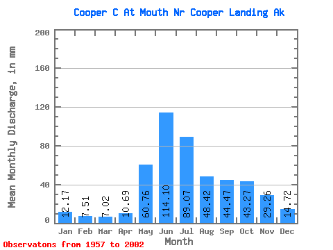
| Units: | m3/s |
| Statistic | Jan | Feb | Mar | Apr | May | Jun | Jul | Aug | Sep | Oct | Nov | Dec | Annual |
|---|---|---|---|---|---|---|---|---|---|---|---|---|---|
| Mean | 12.16 | 7.58 | 7.01 | 10.69 | 60.74 | 114.10 | 89.06 | 48.41 | 44.47 | 43.26 | 29.25 | 14.73 | 473.54 |
| Standard Deviation | 8.98 | 4.49 | 4.60 | 7.59 | 37.46 | 71.58 | 60.63 | 41.85 | 46.82 | 45.35 | 43.84 | 12.81 | 301.24 |
| Min | 4.83 | 3.53 | 2.71 | 5.24 | 25.67 | 42.97 | 40.99 | 22.87 | 12.59 | 12.47 | 6.92 | 6.02 | 199.84 |
| Max | 35.45 | 17.76 | 16.87 | 29.32 | 131.69 | 240.40 | 196.31 | 136.28 | 180.31 | 159.09 | 166.15 | 49.93 | 1012.00 |
| Coefficient of Variation | 0.74 | 0.59 | 0.66 | 0.71 | 0.62 | 0.63 | 0.68 | 0.86 | 1.05 | 1.05 | 1.50 | 0.87 | 0.64 |
 Return to R-Arctic Net Home Page