|
|
|||||||||||||||||
| Point ID: 9477 | Downloads | Plots | Site Data | Code: 15261000 |
|
|
|||||||||||||||||
| Download | |
|---|---|
| Site Descriptor Information | Site Time Series Data |
| Link to all available data | |
| View: | Time Series | All |
| Units: | mm |
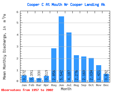
| Statistic | Jan | Feb | Mar | Apr | May | Jun | Jul | Aug | Sep | Oct | Nov | Dec | Annual |
|---|---|---|---|---|---|---|---|---|---|---|---|---|---|
| Mean | 0.57 | 0.39 | 0.33 | 0.52 | 2.86 | 5.54 | 4.19 | 2.28 | 2.16 | 2.03 | 1.42 | 0.69 | 1.89 |
| Standard Deviation | 0.42 | 0.23 | 0.22 | 0.37 | 1.76 | 3.48 | 2.85 | 1.97 | 2.27 | 2.13 | 2.13 | 0.60 | 1.20 |
| Min | 0.23 | 0.18 | 0.13 | 0.26 | 1.21 | 2.09 | 1.93 | 1.07 | 0.61 | 0.59 | 0.34 | 0.28 | 0.80 |
| Max | 1.67 | 0.92 | 0.79 | 1.42 | 6.19 | 11.68 | 9.23 | 6.41 | 8.76 | 7.48 | 8.07 | 2.35 | 4.04 |
| Coefficient of Variation | 0.74 | 0.59 | 0.66 | 0.71 | 0.62 | 0.63 | 0.68 | 0.86 | 1.05 | 1.05 | 1.50 | 0.87 | 0.64 |
 Return to R-Arctic Net Home Page