|
|
|||||||||||||||||
| Point ID: 9477 | Downloads | Plots | Site Data | Code: 15261000 |
|
|
|||||||||||||||||
| Download | |
|---|---|
| Site Descriptor Information | Site Time Series Data |
| Link to all available data | |
|
|
| View: | Statistics | Time Series |
| Units: | m3/s |
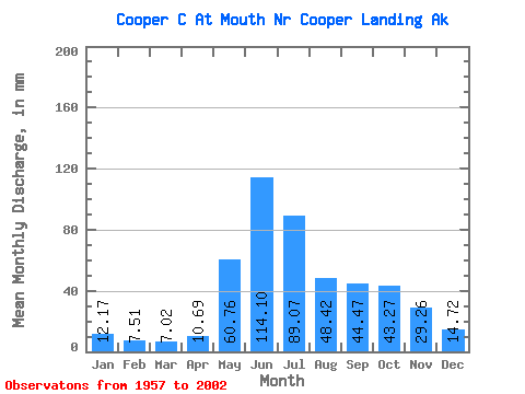
| Statistic | Jan | Feb | Mar | Apr | May | Jun | Jul | Aug | Sep | Oct | Nov | Dec | Annual |
|---|---|---|---|---|---|---|---|---|---|---|---|---|---|
| Mean | 12.16 | 7.58 | 7.01 | 10.69 | 60.74 | 114.10 | 89.06 | 48.41 | 44.47 | 43.26 | 29.25 | 14.73 | 473.54 |
| Standard Deviation | 8.98 | 4.49 | 4.60 | 7.59 | 37.46 | 71.58 | 60.63 | 41.85 | 46.82 | 45.35 | 43.84 | 12.81 | 301.24 |
| Min | 4.83 | 3.53 | 2.71 | 5.24 | 25.67 | 42.97 | 40.99 | 22.87 | 12.59 | 12.47 | 6.92 | 6.02 | 199.84 |
| Max | 35.45 | 17.76 | 16.87 | 29.32 | 131.69 | 240.40 | 196.31 | 136.28 | 180.31 | 159.09 | 166.15 | 49.93 | 1012.00 |
| Coefficient of Variation | 0.74 | 0.59 | 0.66 | 0.71 | 0.62 | 0.63 | 0.68 | 0.86 | 1.05 | 1.05 | 1.50 | 0.87 | 0.64 |
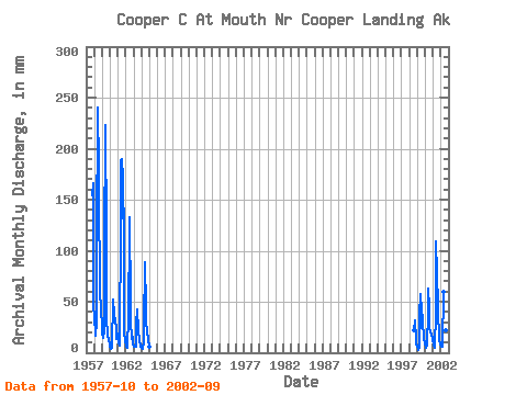
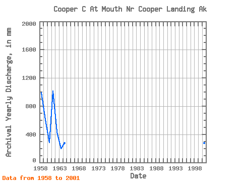
| Year | Jan | Feb | Mar | Apr | May | Jun | Jul | Aug | Sep | Oct | Nov | Dec | Annual | 1957 | 159.09 | 166.15 | 49.93 | 1958 | 35.45 | 17.76 | 16.87 | 29.32 | 110.94 | 240.40 | 186.16 | 135.66 | 88.15 | 64.49 | 39.18 | 29.29 | 990.51 | 1959 | 19.33 | 14.31 | 15.02 | 21.18 | 105.47 | 223.50 | 118.95 | 27.34 | 24.25 | 17.64 | 13.72 | 8.70 | 609.06 | 1960 | 6.31 | 4.13 | 4.21 | 5.24 | 54.25 | 50.84 | 40.99 | 32.72 | 33.93 | 22.27 | 13.16 | 17.35 | 284.03 | 1961 | 19.84 | 8.61 | 6.93 | 9.61 | 131.69 | 188.34 | 196.31 | 136.28 | 180.31 | 106.63 | 21.58 | 10.23 | 1012.00 | 1962 | 8.42 | 6.03 | 4.83 | 7.00 | 35.09 | 123.42 | 137.41 | 48.07 | 30.37 | 13.85 | 15.15 | 7.83 | 435.94 | 1963 | 6.62 | 6.03 | 6.62 | 5.83 | 27.84 | 42.97 | 43.88 | 22.87 | 12.59 | 12.47 | 6.92 | 6.02 | 199.84 | 1964 | 4.83 | 3.84 | 3.62 | 10.39 | 25.67 | 88.42 | 45.41 | 31.64 | 19.55 | 21.63 | 12.57 | 6.79 | 274.06 | 1965 | 6.02 | 1998 | 23.24 | 32.08 | 26.73 | 18.81 | 8.84 | 1999 | 5.95 | 3.53 | 2.71 | 5.84 | 37.67 | 57.05 | 41.86 | 25.03 | 36.73 | 31.15 | 13.19 | 9.23 | 269.12 | 2000 | 8.35 | 6.28 | 5.18 | 8.05 | 39.83 | 63.20 | 45.67 | 26.52 | 20.23 | 19.78 | 17.72 | 14.05 | 274.11 | 2001 | 14.63 | 6.80 | 5.46 | 7.96 | 38.55 | 108.86 | 80.47 | 48.67 | 31.66 | 23.43 | 12.79 | 8.49 | 386.71 | 2002 | 10.18 | 6.05 | 5.70 | 7.13 | 61.18 | 68.07 | 42.58 | 22.87 | 23.80 |
|---|
 Return to R-Arctic Net Home Page