|
|
|||||||||||||||||
| Point ID: 9474 | Downloads | Plots | Site Data | Code: 15008000 |
|
|
|||||||||||||||||
| Download | |
|---|---|
| Site Descriptor Information | Site Time Series Data |
| Link to all available data | |
| View: | Time Series | All |
| Units: | m3/s |
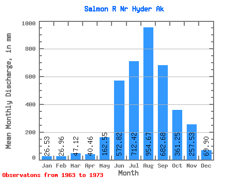
| Statistic | Jan | Feb | Mar | Apr | May | Jun | Jul | Aug | Sep | Oct | Nov | Dec | Annual |
|---|---|---|---|---|---|---|---|---|---|---|---|---|---|
| Mean | 26.53 | 27.19 | 47.11 | 40.46 | 162.53 | 572.82 | 712.31 | 954.53 | 682.68 | 361.20 | 257.52 | 69.89 | 3891.54 |
| Standard Deviation | 20.65 | 31.07 | 70.94 | 19.75 | 57.56 | 255.14 | 141.93 | 474.98 | 447.23 | 353.27 | 356.04 | 102.67 | 391.56 |
| Min | 9.30 | 6.62 | 9.06 | 15.59 | 77.15 | 340.79 | 459.73 | 598.05 | 324.04 | 140.13 | 40.34 | 8.23 | 3403.51 |
| Max | 66.48 | 111.28 | 242.25 | 90.73 | 247.54 | 1212.35 | 968.15 | 2077.52 | 1745.73 | 1353.70 | 936.22 | 352.08 | 4586.44 |
| Coefficient of Variation | 0.78 | 1.14 | 1.51 | 0.49 | 0.35 | 0.45 | 0.20 | 0.50 | 0.66 | 0.98 | 1.38 | 1.47 | 0.10 |
 Return to R-Arctic Net Home Page