|
|
|||||||||||||||||
| Point ID: 9474 | Downloads | Plots | Site Data | Code: 15008000 |
|
|
|||||||||||||||||
| Download | |
|---|---|
| Site Descriptor Information | Site Time Series Data |
| Link to all available data | |
| View: | Time Series | All |
| Units: | mm |
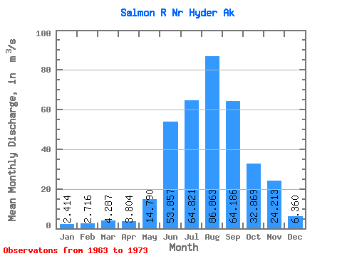
| Statistic | Jan | Feb | Mar | Apr | May | Jun | Jul | Aug | Sep | Oct | Nov | Dec | Annual |
|---|---|---|---|---|---|---|---|---|---|---|---|---|---|
| Mean | 2.41 | 2.72 | 4.29 | 3.80 | 14.79 | 53.86 | 64.82 | 86.86 | 64.19 | 32.87 | 24.21 | 6.36 | 30.05 |
| Standard Deviation | 1.88 | 3.10 | 6.46 | 1.86 | 5.24 | 23.99 | 12.92 | 43.22 | 42.05 | 32.15 | 33.48 | 9.34 | 3.02 |
| Min | 0.85 | 0.66 | 0.82 | 1.47 | 7.02 | 32.04 | 41.84 | 54.42 | 30.47 | 12.75 | 3.79 | 0.75 | 26.28 |
| Max | 6.05 | 11.11 | 22.05 | 8.53 | 22.53 | 113.98 | 88.10 | 189.06 | 164.13 | 123.19 | 88.02 | 32.04 | 35.42 |
| Coefficient of Variation | 0.78 | 1.14 | 1.51 | 0.49 | 0.35 | 0.45 | 0.20 | 0.50 | 0.66 | 0.98 | 1.38 | 1.47 | 0.10 |
 Return to R-Arctic Net Home Page