|
|
|||||||||||||||||
| Point ID: 9474 | Downloads | Plots | Site Data | Code: 15008000 |
|
|
|||||||||||||||||
| Download | |
|---|---|
| Site Descriptor Information | Site Time Series Data |
| Link to all available data | |
|
|
| View: | Statistics | Time Series |
| Units: | m3/s |
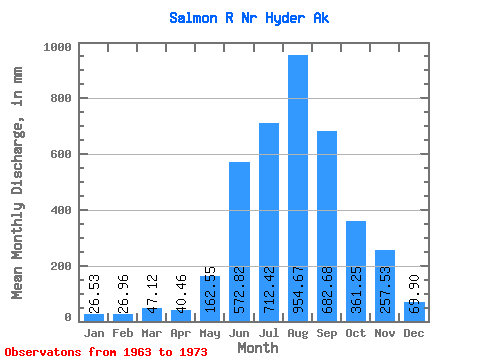
| Statistic | Jan | Feb | Mar | Apr | May | Jun | Jul | Aug | Sep | Oct | Nov | Dec | Annual |
|---|---|---|---|---|---|---|---|---|---|---|---|---|---|
| Mean | 26.53 | 27.19 | 47.11 | 40.46 | 162.53 | 572.82 | 712.31 | 954.53 | 682.68 | 361.20 | 257.52 | 69.89 | 3891.54 |
| Standard Deviation | 20.65 | 31.07 | 70.94 | 19.75 | 57.56 | 255.14 | 141.93 | 474.98 | 447.23 | 353.27 | 356.04 | 102.67 | 391.56 |
| Min | 9.30 | 6.62 | 9.06 | 15.59 | 77.15 | 340.79 | 459.73 | 598.05 | 324.04 | 140.13 | 40.34 | 8.23 | 3403.51 |
| Max | 66.48 | 111.28 | 242.25 | 90.73 | 247.54 | 1212.35 | 968.15 | 2077.52 | 1745.73 | 1353.70 | 936.22 | 352.08 | 4586.44 |
| Coefficient of Variation | 0.78 | 1.14 | 1.51 | 0.49 | 0.35 | 0.45 | 0.20 | 0.50 | 0.66 | 0.98 | 1.38 | 1.47 | 0.10 |
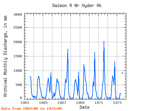
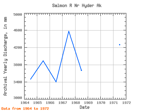
| Year | Jan | Feb | Mar | Apr | May | Jun | Jul | Aug | Sep | Oct | Nov | Dec | Annual | 1963 | 804.93 | 763.69 | 253.56 | 91.63 | 105.67 | 1964 | 38.22 | 111.28 | 56.98 | 36.03 | 116.45 | 660.58 | 828.21 | 794.49 | 360.27 | 335.16 | 92.86 | 49.89 | 3466.18 | 1965 | 58.72 | 33.41 | 23.46 | 47.84 | 115.71 | 340.79 | 653.46 | 755.54 | 368.97 | 239.78 | 919.50 | 352.08 | 3897.04 | 1966 | 66.48 | 33.12 | 242.25 | 90.73 | 205.27 | 394.14 | 738.38 | 603.87 | 609.18 | 296.24 | 119.28 | 23.19 | 3403.51 | 1967 | 15.56 | 11.34 | 10.89 | 38.64 | 247.54 | 692.71 | 595.74 | 806.54 | 1745.73 | 311.21 | 73.11 | 35.41 | 4586.44 | 1968 | 13.40 | 17.93 | 22.92 | 33.99 | 208.32 | 544.93 | 719.61 | 598.05 | 398.02 | 140.13 | 936.22 | 40.33 | 3672.07 | 1969 | 9.30 | 6.62 | 9.97 | 25.65 | 205.17 | 1212.35 | 968.15 | 681.98 | 528.18 | 192.44 | 195.20 | 39.69 | 4066.21 | 1970 | 18.33 | 23.70 | 28.06 | 38.01 | 155.25 | 608.78 | 459.73 | 1678.82 | 324.04 | 248.59 | 40.34 | 17.02 | 3610.63 | 1971 | 14.15 | 8.55 | 9.06 | 36.06 | 98.60 | 441.14 | 688.99 | 2077.52 | 604.54 | 241.17 | 57.40 | 27.42 | 4265.38 | 1972 | 18.53 | 16.06 | 57.30 | 15.59 | 77.15 | 398.23 | 833.43 | 764.58 | 504.25 | 1353.70 | 49.71 | 8.23 | 4056.42 | 1973 | 12.61 | 9.88 | 10.22 | 42.04 | 195.78 | 434.56 | 637.40 | 933.51 | 1302.59 |
|---|
 Return to R-Arctic Net Home Page