|
|
|||||||||||||||||
| Point ID: 9418 | Downloads | Plots | Site Data | Code: 15516000 |
|
|
|||||||||||||||||
| Download | |
|---|---|
| Site Descriptor Information | Site Time Series Data |
| Link to all available data | |
| View: | Time Series | All |
| Units: | m3/s |
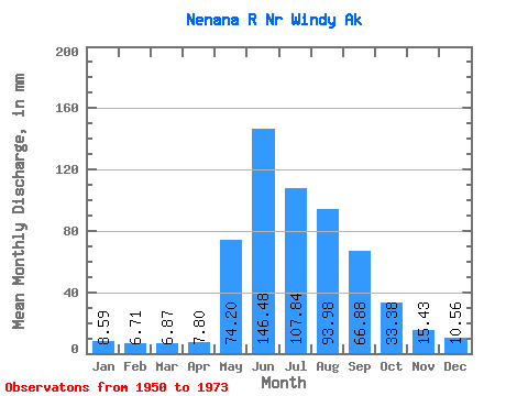
| Statistic | Jan | Feb | Mar | Apr | May | Jun | Jul | Aug | Sep | Oct | Nov | Dec | Annual |
|---|---|---|---|---|---|---|---|---|---|---|---|---|---|
| Mean | 8.59 | 6.76 | 6.87 | 7.80 | 74.19 | 146.48 | 107.82 | 93.96 | 66.88 | 33.37 | 15.43 | 10.56 | 582.19 |
| Standard Deviation | 2.13 | 1.49 | 1.41 | 1.44 | 26.23 | 46.06 | 26.80 | 25.84 | 22.30 | 7.89 | 4.43 | 2.70 | 91.03 |
| Min | 3.40 | 3.00 | 3.41 | 5.99 | 12.84 | 57.93 | 52.24 | 37.11 | 26.16 | 18.72 | 5.68 | 3.84 | 340.03 |
| Max | 12.87 | 9.61 | 9.46 | 11.68 | 115.43 | 260.25 | 157.98 | 138.03 | 110.67 | 47.25 | 20.91 | 15.22 | 713.54 |
| Coefficient of Variation | 0.25 | 0.22 | 0.20 | 0.18 | 0.35 | 0.31 | 0.25 | 0.28 | 0.33 | 0.24 | 0.29 | 0.26 | 0.16 |
 Return to R-Arctic Net Home Page