|
|
|||||||||||||||||
| Point ID: 9418 | Downloads | Plots | Site Data | Code: 15516000 |
|
|
|||||||||||||||||
| Download | |
|---|---|
| Site Descriptor Information | Site Time Series Data |
| Link to all available data | |
| View: | Time Series | All |
| Units: | mm |
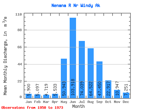
| Statistic | Jan | Feb | Mar | Apr | May | Jun | Jul | Aug | Sep | Oct | Nov | Dec | Annual |
|---|---|---|---|---|---|---|---|---|---|---|---|---|---|
| Mean | 5.90 | 5.10 | 4.72 | 5.53 | 50.94 | 103.92 | 74.04 | 64.52 | 47.45 | 22.92 | 10.95 | 7.25 | 33.92 |
| Standard Deviation | 1.47 | 1.12 | 0.97 | 1.02 | 18.01 | 32.67 | 18.40 | 17.74 | 15.82 | 5.42 | 3.14 | 1.85 | 5.30 |
| Min | 2.33 | 2.27 | 2.34 | 4.25 | 8.81 | 41.10 | 35.87 | 25.48 | 18.56 | 12.86 | 4.03 | 2.64 | 19.81 |
| Max | 8.84 | 7.24 | 6.50 | 8.29 | 79.26 | 184.63 | 108.48 | 94.78 | 78.51 | 32.44 | 14.84 | 10.45 | 41.58 |
| Coefficient of Variation | 0.25 | 0.22 | 0.20 | 0.18 | 0.35 | 0.31 | 0.25 | 0.28 | 0.33 | 0.24 | 0.29 | 0.26 | 0.16 |
 Return to R-Arctic Net Home Page