|
|
|||||||||||||||||
| Point ID: 9418 | Downloads | Plots | Site Data | Code: 15516000 |
|
|
|||||||||||||||||
| Download | |
|---|---|
| Site Descriptor Information | Site Time Series Data |
| Link to all available data | |
|
|
| View: | Statistics | Time Series |
| Units: | m3/s |
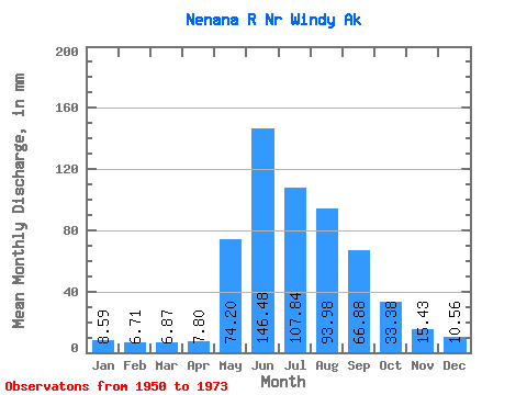
| Statistic | Jan | Feb | Mar | Apr | May | Jun | Jul | Aug | Sep | Oct | Nov | Dec | Annual |
|---|---|---|---|---|---|---|---|---|---|---|---|---|---|
| Mean | 8.59 | 6.76 | 6.87 | 7.80 | 74.19 | 146.48 | 107.82 | 93.96 | 66.88 | 33.37 | 15.43 | 10.56 | 582.19 |
| Standard Deviation | 2.13 | 1.49 | 1.41 | 1.44 | 26.23 | 46.06 | 26.80 | 25.84 | 22.30 | 7.89 | 4.43 | 2.70 | 91.03 |
| Min | 3.40 | 3.00 | 3.41 | 5.99 | 12.84 | 57.93 | 52.24 | 37.11 | 26.16 | 18.72 | 5.68 | 3.84 | 340.03 |
| Max | 12.87 | 9.61 | 9.46 | 11.68 | 115.43 | 260.25 | 157.98 | 138.03 | 110.67 | 47.25 | 20.91 | 15.22 | 713.54 |
| Coefficient of Variation | 0.25 | 0.22 | 0.20 | 0.18 | 0.35 | 0.31 | 0.25 | 0.28 | 0.33 | 0.24 | 0.29 | 0.26 | 0.16 |
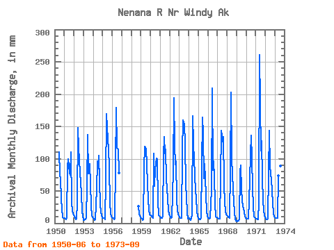
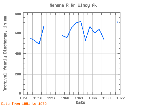
| Year | Jan | Feb | Mar | Apr | May | Jun | Jul | Aug | Sep | Oct | Nov | Dec | Annual | 1950 | 110.48 | 78.41 | 70.34 | 38.63 | 22.66 | 9.18 | 8.45 | 1951 | 8.03 | 6.19 | 6.40 | 9.31 | 90.79 | 99.67 | 80.24 | 77.11 | 110.67 | 31.37 | 20.30 | 15.22 | 553.76 | 1952 | 10.31 | 7.14 | 6.60 | 6.99 | 32.39 | 148.23 | 120.44 | 80.19 | 64.01 | 47.25 | 19.16 | 11.96 | 553.16 | 1953 | 5.36 | 4.13 | 5.77 | 8.78 | 59.40 | 136.62 | 79.75 | 86.28 | 91.44 | 28.65 | 11.18 | 9.48 | 525.89 | 1954 | 8.25 | 6.24 | 5.36 | 5.99 | 53.90 | 96.05 | 86.85 | 108.69 | 65.31 | 30.95 | 18.16 | 8.62 | 492.16 | 1955 | 8.25 | 7.51 | 7.83 | 6.39 | 69.36 | 168.91 | 133.45 | 118.21 | 86.80 | 32.29 | 14.57 | 10.31 | 661.72 | 1956 | 8.66 | 7.14 | 6.60 | 6.59 | 89.73 | 179.45 | 120.58 | 117.93 | 77.43 | 1958 | 27.69 | 14.37 | 9.12 | 1959 | 8.01 | 6.21 | 5.15 | 6.39 | 87.69 | 119.16 | 119.14 | 92.25 | 61.79 | 37.44 | 20.91 | 14.13 | 575.28 | 1960 | 12.87 | 9.61 | 9.46 | 8.53 | 111.56 | 57.93 | 87.58 | 103.88 | 97.86 | 34.52 | 12.59 | 12.01 | 555.07 | 1961 | 10.97 | 7.25 | 8.15 | 11.68 | 107.87 | 134.38 | 111.72 | 118.74 | 68.39 | 39.67 | 20.38 | 13.86 | 649.70 | 1962 | 11.69 | 8.21 | 8.02 | 9.41 | 84.05 | 194.06 | 125.51 | 93.72 | 96.38 | 38.43 | 19.27 | 11.55 | 698.92 | 1963 | 9.48 | 7.89 | 7.83 | 8.38 | 115.43 | 159.16 | 157.98 | 127.34 | 58.09 | 42.59 | 16.16 | 7.42 | 713.54 | 1964 | 7.83 | 5.64 | 5.36 | 7.58 | 12.84 | 165.76 | 127.00 | 77.09 | 50.02 | 42.12 | 17.93 | 11.17 | 529.25 | 1965 | 7.90 | 6.01 | 6.60 | 9.58 | 90.48 | 163.53 | 143.27 | 71.30 | 91.80 | 45.79 | 17.96 | 11.13 | 663.23 | 1966 | 8.66 | 7.14 | 7.42 | 7.98 | 54.01 | 209.23 | 84.72 | 99.53 | 71.48 | 32.07 | 10.40 | 9.21 | 601.50 | 1967 | 8.07 | 6.71 | 6.79 | 6.60 | 72.19 | 143.50 | 130.43 | 138.03 | 61.17 | 33.22 | 19.00 | 13.84 | 636.24 | 1968 | 11.41 | 9.02 | 8.95 | 8.37 | 85.87 | 202.69 | 102.80 | 53.60 | 32.52 | 18.72 | 5.68 | 3.84 | 542.72 | 1969 | 3.40 | 3.00 | 3.41 | 7.16 | 81.41 | 89.94 | 52.24 | 37.11 | 26.16 | 18.74 | 10.50 | 8.43 | 340.03 | 1970 | 7.56 | 6.59 | 7.01 | 7.34 | 68.51 | 106.70 | 140.99 | 103.29 | 54.98 | 27.49 | 10.74 | 8.17 | 546.01 | 1971 | 7.14 | 6.28 | 6.60 | 6.05 | 33.80 | 260.25 | 115.61 | 131.39 | 70.54 | 36.34 | 19.68 | 12.72 | 705.96 | 1972 | 7.12 | 6.01 | 6.60 | 6.51 | 80.16 | 143.04 | 90.67 | 69.51 | 49.69 | 32.84 | 15.93 | 11.11 | 517.45 | 1973 | 9.43 | 8.09 | 8.41 | 8.17 | 76.52 | 133.74 | 82.74 | 91.68 | 46.27 |
|---|
 Return to R-Arctic Net Home Page