|
|
|||||||||||||||||
| Point ID: 9417 | Downloads | Plots | Site Data | Code: 15668200 |
|
|
|||||||||||||||||
| Download | |
|---|---|
| Site Descriptor Information | Site Time Series Data |
| Link to all available data | |
| View: | Time Series | All |
| Units: | m3/s |
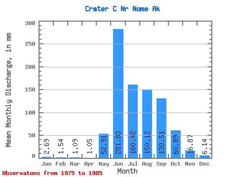
| Statistic | Jan | Feb | Mar | Apr | May | Jun | Jul | Aug | Sep | Oct | Nov | Dec | Annual |
|---|---|---|---|---|---|---|---|---|---|---|---|---|---|
| Mean | 2.69 | 1.55 | 1.08 | 1.06 | 52.88 | 281.81 | 160.39 | 150.09 | 130.52 | 60.88 | 16.89 | 6.16 | 842.37 |
| Standard Deviation | 1.89 | 1.66 | 1.73 | 1.70 | 46.03 | 106.76 | 95.34 | 83.43 | 85.93 | 39.03 | 6.97 | 2.14 | 269.08 |
| Min | 0.62 | 0.00 | 0.00 | 0.00 | 12.43 | 133.77 | 95.50 | 88.14 | 24.94 | 22.47 | 6.34 | 3.35 | 577.69 |
| Max | 6.83 | 5.59 | 5.34 | 5.17 | 147.38 | 466.40 | 395.42 | 362.53 | 294.45 | 141.47 | 29.52 | 10.49 | 1456.42 |
| Coefficient of Variation | 0.70 | 1.07 | 1.60 | 1.61 | 0.87 | 0.38 | 0.59 | 0.56 | 0.66 | 0.64 | 0.41 | 0.35 | 0.32 |
 Return to R-Arctic Net Home Page