|
|
|||||||||||||||||
| Point ID: 9417 | Downloads | Plots | Site Data | Code: 15668200 |
|
|
|||||||||||||||||
| Download | |
|---|---|
| Site Descriptor Information | Site Time Series Data |
| Link to all available data | |
| View: | Time Series | All |
| Units: | mm |
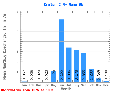
| Statistic | Jan | Feb | Mar | Apr | May | Jun | Jul | Aug | Sep | Oct | Nov | Dec | Annual |
|---|---|---|---|---|---|---|---|---|---|---|---|---|---|
| Mean | 0.06 | 0.04 | 0.02 | 0.02 | 1.12 | 6.17 | 3.40 | 3.18 | 2.85 | 1.29 | 0.37 | 0.13 | 1.51 |
| Standard Deviation | 0.04 | 0.04 | 0.04 | 0.04 | 0.97 | 2.33 | 2.02 | 1.77 | 1.88 | 0.83 | 0.15 | 0.04 | 0.48 |
| Min | 0.01 | 0.00 | 0.00 | 0.00 | 0.26 | 2.93 | 2.02 | 1.87 | 0.55 | 0.48 | 0.14 | 0.07 | 1.04 |
| Max | 0.14 | 0.13 | 0.11 | 0.11 | 3.12 | 10.20 | 8.37 | 7.68 | 6.44 | 3.00 | 0.65 | 0.22 | 2.62 |
| Coefficient of Variation | 0.70 | 1.07 | 1.60 | 1.61 | 0.87 | 0.38 | 0.59 | 0.56 | 0.66 | 0.64 | 0.41 | 0.35 | 0.32 |
 Return to R-Arctic Net Home Page