|
|
|||||||||||||||||
| Point ID: 9417 | Downloads | Plots | Site Data | Code: 15668200 |
|
|
|||||||||||||||||
| Download | |
|---|---|
| Site Descriptor Information | Site Time Series Data |
| Link to all available data | |
|
|
| View: | Statistics | Time Series |
| Units: | m3/s |
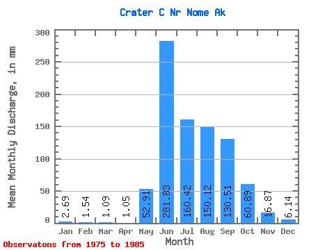
| Statistic | Jan | Feb | Mar | Apr | May | Jun | Jul | Aug | Sep | Oct | Nov | Dec | Annual |
|---|---|---|---|---|---|---|---|---|---|---|---|---|---|
| Mean | 2.69 | 1.55 | 1.08 | 1.06 | 52.88 | 281.81 | 160.39 | 150.09 | 130.52 | 60.88 | 16.89 | 6.16 | 842.37 |
| Standard Deviation | 1.89 | 1.66 | 1.73 | 1.70 | 46.03 | 106.76 | 95.34 | 83.43 | 85.93 | 39.03 | 6.97 | 2.14 | 269.08 |
| Min | 0.62 | 0.00 | 0.00 | 0.00 | 12.43 | 133.77 | 95.50 | 88.14 | 24.94 | 22.47 | 6.34 | 3.35 | 577.69 |
| Max | 6.83 | 5.59 | 5.34 | 5.17 | 147.38 | 466.40 | 395.42 | 362.53 | 294.45 | 141.47 | 29.52 | 10.49 | 1456.42 |
| Coefficient of Variation | 0.70 | 1.07 | 1.60 | 1.61 | 0.87 | 0.38 | 0.59 | 0.56 | 0.66 | 0.64 | 0.41 | 0.35 | 0.32 |
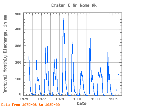
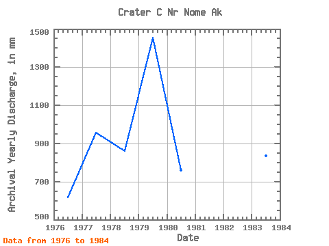
| Year | Jan | Feb | Mar | Apr | May | Jun | Jul | Aug | Sep | Oct | Nov | Dec | Annual | 1975 | 240.74 | 106.50 | 32.70 | 13.64 | 8.85 | 1976 | 6.83 | 5.59 | 5.34 | 5.17 | 25.59 | 214.15 | 95.50 | 92.07 | 96.83 | 50.18 | 14.32 | 6.04 | 617.85 | 1977 | 3.42 | 1.96 | 1.32 | 1.28 | 34.82 | 287.33 | 96.82 | 106.22 | 294.45 | 103.42 | 17.50 | 7.09 | 958.25 | 1978 | 3.12 | 1.64 | 1.09 | 1.25 | 117.87 | 216.05 | 119.40 | 98.49 | 220.88 | 55.62 | 16.95 | 10.49 | 862.38 | 1979 | 4.72 | 2.93 | 2.69 | 2.71 | 29.00 | 466.40 | 395.42 | 362.53 | 103.08 | 60.84 | 27.40 | 5.11 | 1456.42 | 1980 | 1.73 | 0.60 | 0.19 | 0.00 | 26.21 | 322.63 | 247.73 | 96.60 | 24.94 | 22.47 | 14.02 | 4.84 | 760.14 | 1981 | 1.73 | 0.71 | 0.21 | 0.04 | 78.41 | 155.12 | 117.42 | 128.61 | 54.72 | 27.79 | 11.48 | 4.56 | 577.69 | 1982 | 1.58 | 0.67 | 0.00 | 0.00 | 12.43 | 379.41 | 180.09 | 88.14 | 122.72 | 87.75 | 29.52 | 6.22 | 909.62 | 1983 | 1.80 | 0.82 | 0.00 | 0.11 | 147.38 | 133.77 | 110.38 | 172.78 | 109.60 | 141.47 | 17.69 | 5.06 | 834.39 | 1984 | 0.62 | 0.00 | 0.00 | 0.00 | 21.96 | 261.41 | 97.06 | 131.75 | 55.88 | 26.54 | 6.34 | 3.35 | 604.62 | 1985 | 1.30 | 0.56 | 0.00 | 0.00 | 35.14 | 381.79 | 144.10 | 133.01 | 246.13 |
|---|
 Return to R-Arctic Net Home Page