|
|
|||||||||||||||||
| Point ID: 9279 | Downloads | Plots | Site Data | Code: 15024800 |
|
|
|||||||||||||||||
| Download | |
|---|---|
| Site Descriptor Information | Site Time Series Data |
| Link to all available data | |
| View: | Time Series | All |
| Units: | m3/s |
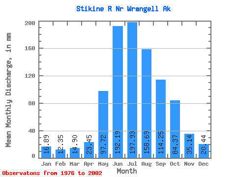
| Statistic | Jan | Feb | Mar | Apr | May | Jun | Jul | Aug | Sep | Oct | Nov | Dec | Annual |
|---|---|---|---|---|---|---|---|---|---|---|---|---|---|
| Mean | 16.89 | 12.45 | 14.90 | 23.45 | 97.70 | 192.19 | 197.90 | 158.67 | 114.25 | 84.36 | 35.14 | 20.44 | 963.16 |
| Standard Deviation | 9.92 | 4.54 | 10.68 | 7.47 | 36.01 | 31.39 | 23.39 | 21.14 | 27.21 | 30.36 | 16.68 | 8.11 | 109.92 |
| Min | 8.76 | 6.84 | 6.94 | 10.37 | 47.41 | 147.09 | 160.35 | 112.84 | 72.22 | 44.96 | 14.24 | 8.22 | 777.01 |
| Max | 57.98 | 25.55 | 62.23 | 45.47 | 175.09 | 284.34 | 240.77 | 197.19 | 182.95 | 166.56 | 82.92 | 37.89 | 1184.54 |
| Coefficient of Variation | 0.59 | 0.36 | 0.72 | 0.32 | 0.37 | 0.16 | 0.12 | 0.13 | 0.24 | 0.36 | 0.47 | 0.40 | 0.11 |
 Return to R-Arctic Net Home Page