|
|
|||||||||||||||||
| Point ID: 9279 | Downloads | Plots | Site Data | Code: 15024800 |
|
|
|||||||||||||||||
| Download | |
|---|---|
| Site Descriptor Information | Site Time Series Data |
| Link to all available data | |
|
|
| View: | Statistics | Time Series |
| Units: | m3/s |
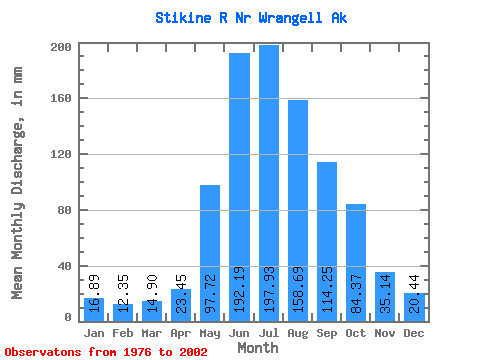
| Statistic | Jan | Feb | Mar | Apr | May | Jun | Jul | Aug | Sep | Oct | Nov | Dec | Annual |
|---|---|---|---|---|---|---|---|---|---|---|---|---|---|
| Mean | 16.89 | 12.45 | 14.90 | 23.45 | 97.70 | 192.19 | 197.90 | 158.67 | 114.25 | 84.36 | 35.14 | 20.44 | 963.16 |
| Standard Deviation | 9.92 | 4.54 | 10.68 | 7.47 | 36.01 | 31.39 | 23.39 | 21.14 | 27.21 | 30.36 | 16.68 | 8.11 | 109.92 |
| Min | 8.76 | 6.84 | 6.94 | 10.37 | 47.41 | 147.09 | 160.35 | 112.84 | 72.22 | 44.96 | 14.24 | 8.22 | 777.01 |
| Max | 57.98 | 25.55 | 62.23 | 45.47 | 175.09 | 284.34 | 240.77 | 197.19 | 182.95 | 166.56 | 82.92 | 37.89 | 1184.54 |
| Coefficient of Variation | 0.59 | 0.36 | 0.72 | 0.32 | 0.37 | 0.16 | 0.12 | 0.13 | 0.24 | 0.36 | 0.47 | 0.40 | 0.11 |
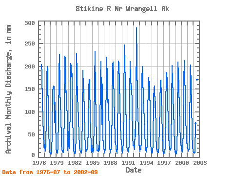
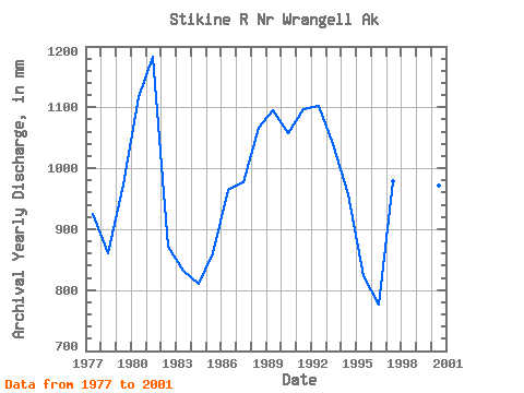
| Year | Jan | Feb | Mar | Apr | May | Jun | Jul | Aug | Sep | Oct | Nov | Dec | Annual | 1976 | 210.19 | 189.22 | 119.83 | 84.97 | 53.11 | 23.18 | 1977 | 20.33 | 25.55 | 13.89 | 29.58 | 86.52 | 177.96 | 206.30 | 197.19 | 79.70 | 58.69 | 21.69 | 11.90 | 925.13 | 1978 | 8.76 | 7.42 | 6.94 | 14.77 | 53.98 | 147.09 | 161.49 | 160.52 | 75.53 | 124.58 | 82.92 | 22.06 | 861.67 | 1979 | 10.91 | 10.41 | 9.73 | 22.93 | 89.59 | 185.80 | 233.47 | 160.42 | 106.34 | 105.20 | 28.07 | 16.97 | 974.45 | 1980 | 12.92 | 10.83 | 10.99 | 24.77 | 104.18 | 222.26 | 223.70 | 175.17 | 114.87 | 150.76 | 57.06 | 15.01 | 1117.09 | 1981 | 57.98 | 24.08 | 19.36 | 19.50 | 138.58 | 206.04 | 206.77 | 183.25 | 182.95 | 72.19 | 59.91 | 17.65 | 1184.54 | 1982 | 8.96 | 7.63 | 8.87 | 12.90 | 47.41 | 227.43 | 191.08 | 131.87 | 115.82 | 84.06 | 23.55 | 14.80 | 871.82 | 1983 | 12.27 | 9.19 | 9.31 | 19.44 | 96.49 | 190.73 | 160.35 | 148.71 | 100.97 | 54.19 | 21.79 | 11.58 | 831.78 | 1984 | 13.83 | 14.10 | 19.07 | 24.55 | 63.25 | 150.95 | 176.57 | 173.06 | 83.49 | 69.47 | 16.99 | 10.49 | 811.54 | 1985 | 27.74 | 11.72 | 11.22 | 15.94 | 77.85 | 168.26 | 240.77 | 146.06 | 90.10 | 44.96 | 14.24 | 16.30 | 860.19 | 1986 | 14.02 | 11.97 | 25.86 | 15.53 | 57.59 | 173.40 | 217.68 | 143.43 | 72.22 | 166.56 | 47.81 | 25.60 | 965.45 | 1987 | 22.15 | 11.77 | 9.90 | 20.15 | 81.22 | 171.49 | 226.69 | 124.77 | 126.44 | 114.60 | 46.42 | 26.52 | 977.54 | 1988 | 9.99 | 13.63 | 17.59 | 27.27 | 116.62 | 202.54 | 216.44 | 180.28 | 125.21 | 95.56 | 32.19 | 34.89 | 1066.92 | 1989 | 20.85 | 13.74 | 8.49 | 24.09 | 172.16 | 211.74 | 211.18 | 168.74 | 115.30 | 78.43 | 39.96 | 37.89 | 1096.87 | 1990 | 15.73 | 8.86 | 18.35 | 30.38 | 126.83 | 246.68 | 205.92 | 180.88 | 122.72 | 65.69 | 22.19 | 18.18 | 1057.97 | 1991 | 13.59 | 13.68 | 12.00 | 30.49 | 140.91 | 210.22 | 180.85 | 153.41 | 156.16 | 118.91 | 43.70 | 27.20 | 1097.07 | 1992 | 25.13 | 15.53 | 62.23 | 45.47 | 115.78 | 284.34 | 220.81 | 128.83 | 90.40 | 66.34 | 32.63 | 19.64 | 1103.54 | 1993 | 12.60 | 17.39 | 17.59 | 34.76 | 175.09 | 198.98 | 176.38 | 137.92 | 102.12 | 93.30 | 53.15 | 26.38 | 1041.25 | 1994 | 15.93 | 10.26 | 16.98 | 26.45 | 97.63 | 156.34 | 180.09 | 162.68 | 165.94 | 85.16 | 27.53 | 17.27 | 958.26 | 1995 | 10.56 | 8.58 | 11.19 | 30.05 | 133.82 | 150.65 | 162.12 | 112.84 | 122.38 | 52.00 | 18.83 | 14.71 | 824.21 | 1996 | 11.45 | 11.03 | 11.10 | 25.37 | 63.98 | 168.28 | 175.46 | 139.81 | 91.78 | 56.06 | 17.54 | 8.22 | 777.01 | 1997 | 8.83 | 8.41 | 9.06 | 24.76 | 107.70 | 187.08 | 187.90 | 173.37 | 137.14 | 66.14 | 40.02 | 33.74 | 980.00 | 1998 | 17.33 | 15.78 | 15.68 | 21.60 | 126.57 | 201.32 | 172.11 | 143.87 | 95.59 | 73.10 | 21.00 | 11.92 | 912.03 | 1999 | 12.90 | 6.84 | 8.05 | 19.20 | 75.84 | 209.14 | 190.84 | 160.53 | 106.38 | 76.72 | 32.09 | 32.10 | 926.57 | 2000 | 20.67 | 13.03 | 11.21 | 20.84 | 62.58 | 166.49 | 219.29 | 170.07 | 149.62 | 82.09 | 37.70 | 22.80 | 972.33 | 2001 | 22.58 | 12.20 | 13.69 | 18.59 | 51.24 | 190.35 | 209.19 | 161.08 | 118.47 | 53.61 | 21.63 | 14.41 | 883.70 | 2002 | 11.04 | 10.13 | 9.03 | 10.37 | 76.91 | 191.30 | 179.69 | 176.09 | 117.28 |
|---|
 Return to R-Arctic Net Home Page