|
|
|||||||||||||||||
| Point ID: 9279 | Downloads | Plots | Site Data | Code: 15024800 |
|
|
|||||||||||||||||
| Download | |
|---|---|
| Site Descriptor Information | Site Time Series Data |
| Link to all available data | |
| View: | Time Series | All |
| Units: | mm |
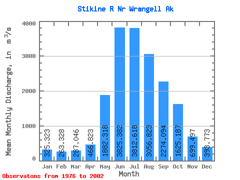
| Statistic | Jan | Feb | Mar | Apr | May | Jun | Jul | Aug | Sep | Oct | Nov | Dec | Annual |
|---|---|---|---|---|---|---|---|---|---|---|---|---|---|
| Mean | 325.32 | 263.33 | 287.05 | 466.82 | 1882.32 | 3825.38 | 3812.62 | 3056.82 | 2274.09 | 1625.19 | 699.50 | 393.77 | 1574.52 |
| Standard Deviation | 191.10 | 95.91 | 205.70 | 148.71 | 693.75 | 624.86 | 450.56 | 407.35 | 541.62 | 584.95 | 332.02 | 156.15 | 179.69 |
| Min | 168.71 | 144.72 | 133.64 | 206.50 | 913.45 | 2927.77 | 3089.19 | 2174.00 | 1437.46 | 866.13 | 283.55 | 158.37 | 1270.22 |
| Max | 1117.05 | 540.14 | 1198.90 | 905.10 | 3373.18 | 5659.59 | 4638.48 | 3798.84 | 3641.55 | 3208.76 | 1650.40 | 730.03 | 1936.41 |
| Coefficient of Variation | 0.59 | 0.36 | 0.72 | 0.32 | 0.37 | 0.16 | 0.12 | 0.13 | 0.24 | 0.36 | 0.47 | 0.40 | 0.11 |
 Return to R-Arctic Net Home Page