|
|
|||||||||||||||||
| Point ID: 9258 | Downloads | Plots | Site Data | Code: 15053800 |
|
|
|||||||||||||||||
| Download | |
|---|---|
| Site Descriptor Information | Site Time Series Data |
| Link to all available data | |
| View: | Time Series | All |
| Units: | m3/s |
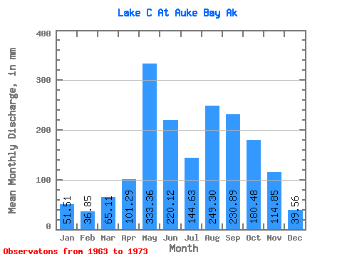
| Statistic | Jan | Feb | Mar | Apr | May | Jun | Jul | Aug | Sep | Oct | Nov | Dec | Annual |
|---|---|---|---|---|---|---|---|---|---|---|---|---|---|
| Mean | 51.52 | 37.05 | 65.07 | 101.31 | 333.44 | 220.17 | 144.69 | 249.12 | 230.73 | 180.37 | 114.86 | 39.45 | 1812.98 |
| Standard Deviation | 71.47 | 36.79 | 54.82 | 32.06 | 113.75 | 133.94 | 83.77 | 108.90 | 132.13 | 48.57 | 81.49 | 27.93 | 348.76 |
| Min | 0.53 | 0.00 | 13.49 | 53.94 | 223.80 | 41.25 | 45.32 | 44.04 | 60.02 | 109.34 | 25.84 | 13.42 | 1435.87 |
| Max | 242.62 | 105.37 | 195.55 | 141.19 | 535.90 | 490.47 | 290.05 | 420.32 | 479.93 | 249.15 | 288.75 | 107.05 | 2316.25 |
| Coefficient of Variation | 1.39 | 0.99 | 0.84 | 0.32 | 0.34 | 0.61 | 0.58 | 0.44 | 0.57 | 0.27 | 0.71 | 0.71 | 0.19 |
 Return to R-Arctic Net Home Page