|
|
|||||||||||||||||
| Point ID: 9258 | Downloads | Plots | Site Data | Code: 15053800 |
|
|
|||||||||||||||||
| Download | |
|---|---|
| Site Descriptor Information | Site Time Series Data |
| Link to all available data | |
| View: | Time Series | All |
| Units: | mm |
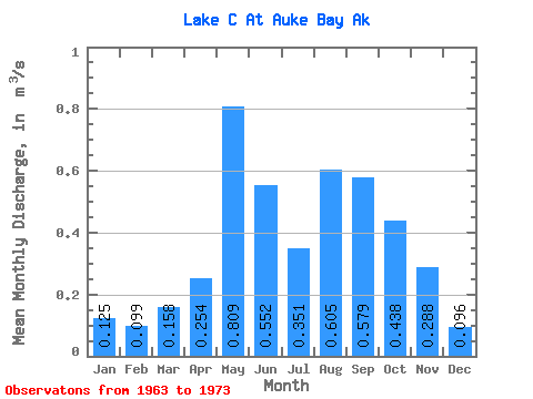
| Statistic | Jan | Feb | Mar | Apr | May | Jun | Jul | Aug | Sep | Oct | Nov | Dec | Annual |
|---|---|---|---|---|---|---|---|---|---|---|---|---|---|
| Mean | 0.12 | 0.10 | 0.16 | 0.25 | 0.81 | 0.55 | 0.35 | 0.60 | 0.58 | 0.44 | 0.29 | 0.10 | 0.37 |
| Standard Deviation | 0.17 | 0.10 | 0.13 | 0.08 | 0.28 | 0.34 | 0.20 | 0.26 | 0.33 | 0.12 | 0.20 | 0.07 | 0.07 |
| Min | 0.00 | 0.00 | 0.03 | 0.14 | 0.54 | 0.10 | 0.11 | 0.11 | 0.15 | 0.27 | 0.07 | 0.03 | 0.30 |
| Max | 0.59 | 0.28 | 0.47 | 0.35 | 1.30 | 1.23 | 0.70 | 1.02 | 1.20 | 0.60 | 0.72 | 0.26 | 0.48 |
| Coefficient of Variation | 1.39 | 0.99 | 0.84 | 0.32 | 0.34 | 0.61 | 0.58 | 0.44 | 0.57 | 0.27 | 0.71 | 0.71 | 0.19 |
 Return to R-Arctic Net Home Page