|
|
|||||||||||||||||
| Point ID: 9258 | Downloads | Plots | Site Data | Code: 15053800 |
|
|
|||||||||||||||||
| Download | |
|---|---|
| Site Descriptor Information | Site Time Series Data |
| Link to all available data | |
|
|
| View: | Statistics | Time Series |
| Units: | m3/s |
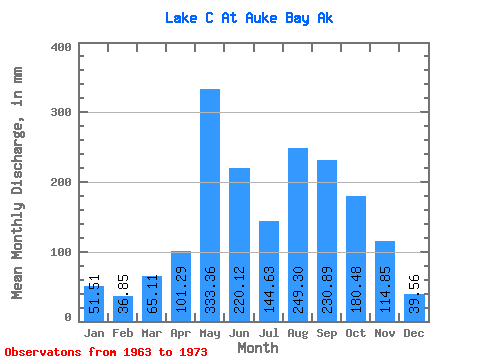
| Statistic | Jan | Feb | Mar | Apr | May | Jun | Jul | Aug | Sep | Oct | Nov | Dec | Annual |
|---|---|---|---|---|---|---|---|---|---|---|---|---|---|
| Mean | 51.52 | 37.05 | 65.07 | 101.31 | 333.44 | 220.17 | 144.69 | 249.12 | 230.73 | 180.37 | 114.86 | 39.45 | 1812.98 |
| Standard Deviation | 71.47 | 36.79 | 54.82 | 32.06 | 113.75 | 133.94 | 83.77 | 108.90 | 132.13 | 48.57 | 81.49 | 27.93 | 348.76 |
| Min | 0.53 | 0.00 | 13.49 | 53.94 | 223.80 | 41.25 | 45.32 | 44.04 | 60.02 | 109.34 | 25.84 | 13.42 | 1435.87 |
| Max | 242.62 | 105.37 | 195.55 | 141.19 | 535.90 | 490.47 | 290.05 | 420.32 | 479.93 | 249.15 | 288.75 | 107.05 | 2316.25 |
| Coefficient of Variation | 1.39 | 0.99 | 0.84 | 0.32 | 0.34 | 0.61 | 0.58 | 0.44 | 0.57 | 0.27 | 0.71 | 0.71 | 0.19 |
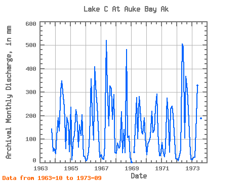
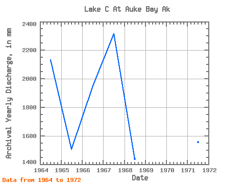
| Year | Jan | Feb | Mar | Apr | May | Jun | Jul | Aug | Sep | Oct | Nov | Dec | Annual | 1963 | 147.46 | 48.73 | 61.77 | 1964 | 38.46 | 105.37 | 195.55 | 133.43 | 318.41 | 348.15 | 287.99 | 243.59 | 60.02 | 199.59 | 165.58 | 47.13 | 2138.14 | 1965 | 242.62 | 10.51 | 105.15 | 116.23 | 232.45 | 197.88 | 68.39 | 165.69 | 114.41 | 210.72 | 25.84 | 28.45 | 1506.88 | 1966 | 7.39 | 11.90 | 47.58 | 115.14 | 368.04 | 219.00 | 99.70 | 420.32 | 289.48 | 249.15 | 111.76 | 23.12 | 1952.32 | 1967 | 34.75 | 14.32 | 13.49 | 72.26 | 535.90 | 323.00 | 160.27 | 337.08 | 312.00 | 189.72 | 288.75 | 42.58 | 2316.25 | 1968 | 41.93 | 79.00 | 63.57 | 67.26 | 223.80 | 41.25 | 145.02 | 44.04 | 479.93 | 109.34 | 112.01 | 23.83 | 1435.87 | 1969 | 0.53 | 0.00 | 46.32 | 141.19 | 285.00 | 101.62 | 290.05 | 232.74 | 128.26 | 125.47 | 190.93 | 107.05 | 1637.90 | 1970 | 33.85 | 73.68 | 95.13 | 110.99 | 226.79 | 127.14 | 144.20 | 238.64 | 291.13 | 130.95 | 29.16 | 29.57 | 1528.89 | 1971 | 87.08 | 46.29 | 26.37 | 70.73 | 282.75 | 211.44 | 45.32 | 233.58 | 240.55 | 208.41 | 93.21 | 17.58 | 1559.59 | 1972 | 15.89 | 7.56 | 34.38 | 53.94 | 521.81 | 490.47 | 108.36 | 380.01 | 308.93 | 232.86 | 82.61 | 13.42 | 2240.95 | 1973 | 12.64 | 21.85 | 23.19 | 131.99 | 339.49 | 141.76 | 97.64 | 195.46 | 82.62 |
|---|
 Return to R-Arctic Net Home Page