|
|
|||||||||||||||||
| Point ID: 9250 | Downloads | Plots | Site Data | Code: 15051010 |
|
|
|||||||||||||||||
| Download | |
|---|---|
| Site Descriptor Information | Site Time Series Data |
| Link to all available data | |
| View: | Time Series | All |
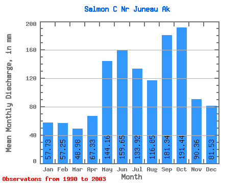
| Units: | m3/s |
| Statistic | Jan | Feb | Mar | Apr | May | Jun | Jul | Aug | Sep | Oct | Nov | Dec | Annual |
|---|---|---|---|---|---|---|---|---|---|---|---|---|---|
| Mean | 57.67 | 57.70 | 48.95 | 67.34 | 144.11 | 159.65 | 133.91 | 116.82 | 181.33 | 191.46 | 90.37 | 81.53 | 1357.65 |
| Standard Deviation | 22.39 | 30.43 | 26.09 | 24.34 | 43.76 | 47.80 | 44.64 | 50.59 | 54.92 | 72.22 | 47.11 | 49.47 | 237.92 |
| Min | 29.16 | 25.23 | 26.91 | 27.84 | 87.52 | 92.61 | 66.26 | 54.85 | 119.99 | 109.46 | 47.54 | 38.48 | 998.22 |
| Max | 101.07 | 123.77 | 117.83 | 112.98 | 215.39 | 242.32 | 208.59 | 230.00 | 316.30 | 396.95 | 224.87 | 209.89 | 1834.30 |
| Coefficient of Variation | 0.39 | 0.53 | 0.53 | 0.36 | 0.30 | 0.30 | 0.33 | 0.43 | 0.30 | 0.38 | 0.52 | 0.61 | 0.17 |
 Return to R-Arctic Net Home Page