|
|
|||||||||||||||||
| Point ID: 9250 | Downloads | Plots | Site Data | Code: 15051010 |
|
|
|||||||||||||||||
| Download | |
|---|---|
| Site Descriptor Information | Site Time Series Data |
| Link to all available data | |
| View: | Time Series | All |
| Units: | mm |
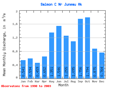
| Statistic | Jan | Feb | Mar | Apr | May | Jun | Jul | Aug | Sep | Oct | Nov | Dec | Annual |
|---|---|---|---|---|---|---|---|---|---|---|---|---|---|
| Mean | 0.54 | 0.59 | 0.46 | 0.65 | 1.35 | 1.55 | 1.25 | 1.09 | 1.76 | 1.79 | 0.88 | 0.76 | 1.08 |
| Standard Deviation | 0.21 | 0.31 | 0.24 | 0.24 | 0.41 | 0.46 | 0.42 | 0.47 | 0.53 | 0.68 | 0.46 | 0.46 | 0.19 |
| Min | 0.27 | 0.26 | 0.25 | 0.27 | 0.82 | 0.90 | 0.62 | 0.51 | 1.16 | 1.03 | 0.46 | 0.36 | 0.79 |
| Max | 0.95 | 1.27 | 1.10 | 1.09 | 2.02 | 2.35 | 1.96 | 2.16 | 3.06 | 3.72 | 2.18 | 1.97 | 1.46 |
| Coefficient of Variation | 0.39 | 0.53 | 0.53 | 0.36 | 0.30 | 0.30 | 0.33 | 0.43 | 0.30 | 0.38 | 0.52 | 0.61 | 0.17 |
 Return to R-Arctic Net Home Page