|
|
| Point ID: 9250 | Downloads | Plots | Site Data | Code: 15051010 |
|
| Download | |
|---|---|
| Site Descriptor Information | Site Time Series Data |
| Link to all available data | |
|
|
|
| View: | Statistics | All |
| Units: | m3/s |
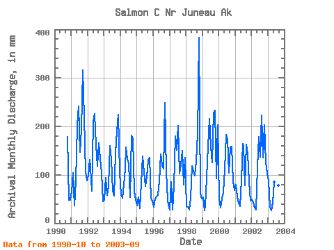
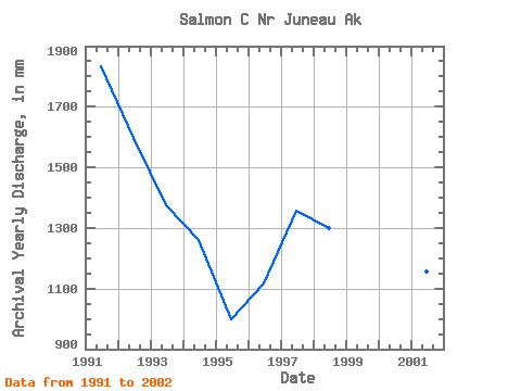
| Year | Jan | Feb | Mar | Apr | May | Jun | Jul | Aug | Sep | Oct | Nov | Dec | Annual | 1990 | 184.29 | 47.54 | 49.43 | 1991 | 67.27 | 98.41 | 37.99 | 86.25 | 209.53 | 242.32 | 151.29 | 201.06 | 316.30 | 226.40 | 105.47 | 91.03 | 1834.30 | 1992 | 101.07 | 123.77 | 117.83 | 66.58 | 215.39 | 226.24 | 166.97 | 122.90 | 165.91 | 138.79 | 103.42 | 46.87 | 1597.26 | 1993 | 50.09 | 87.99 | 60.14 | 76.81 | 164.51 | 132.17 | 68.71 | 58.37 | 143.76 | 198.04 | 224.87 | 107.50 | 1375.62 | 1994 | 61.30 | 49.65 | 81.58 | 112.98 | 162.37 | 132.66 | 128.67 | 54.85 | 182.08 | 180.29 | 64.52 | 50.43 | 1259.56 | 1995 | 37.57 | 51.12 | 32.15 | 82.17 | 142.98 | 104.89 | 78.85 | 100.47 | 129.84 | 139.86 | 50.46 | 48.91 | 998.22 | 1996 | 34.37 | 48.34 | 57.02 | 58.58 | 89.85 | 143.19 | 123.02 | 116.56 | 248.75 | 109.46 | 48.23 | 38.48 | 1116.69 | 1997 | 29.16 | 79.89 | 28.35 | 77.19 | 186.34 | 151.37 | 208.59 | 106.04 | 119.99 | 154.28 | 79.44 | 139.65 | 1357.47 | 1998 | 36.72 | 32.14 | 29.02 | 52.75 | 122.89 | 107.61 | 100.93 | 130.88 | 183.64 | 396.95 | 60.82 | 52.97 | 1300.19 | 1999 | 55.41 | 25.23 | 35.82 | 93.94 | 164.71 | 216.39 | 163.45 | 129.82 | 228.48 | 240.34 | 93.09 | 209.89 | 1649.86 | 2000 | 52.55 | 30.55 | 53.15 | 63.35 | 114.52 | 182.75 | 178.60 | 107.22 | 156.34 | 163.14 | 86.76 | 70.85 | 1256.11 | 2001 | 81.58 | 51.82 | 42.72 | 35.11 | 93.27 | 164.82 | 164.31 | 80.30 | 162.00 | 148.04 | 84.78 | 48.21 | 1155.76 | 2002 | 51.45 | 39.46 | 33.66 | 27.84 | 119.53 | 178.37 | 141.16 | 230.00 | 135.20 | 209.05 | 125.35 | 105.75 | 1390.74 | 2003 | 91.23 | 31.69 | 26.91 | 41.89 | 87.52 | 92.61 | 66.26 | 80.21 | 185.01 |
|---|
 Return to R-Arctic Net Home Page