|
|
|||||||||||||||||
| Point ID: 9218 | Downloads | Plots | Site Data | Code: 15207800 |
|
|
|||||||||||||||||
| Download | |
|---|---|
| Site Descriptor Information | Site Time Series Data |
| Link to all available data | |
| View: | Time Series | All |
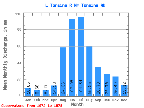
| Units: | m3/s |
| Statistic | Jan | Feb | Mar | Apr | May | Jun | Jul | Aug | Sep | Oct | Nov | Dec | Annual |
|---|---|---|---|---|---|---|---|---|---|---|---|---|---|
| Mean | 10.67 | 8.75 | 8.49 | 14.34 | 64.33 | 102.08 | 104.51 | 66.52 | 38.71 | 29.80 | 26.41 | 15.12 | 515.65 |
| Standard Deviation | 7.63 | 6.21 | 6.39 | 12.13 | 32.90 | 62.92 | 57.27 | 26.97 | 11.33 | 8.24 | 24.92 | 13.35 | 244.38 |
| Min | 4.94 | 4.69 | 4.08 | 3.95 | 28.33 | 46.77 | 57.52 | 44.80 | 26.26 | 16.10 | 9.87 | 8.24 | 290.88 |
| Max | 25.59 | 21.02 | 21.18 | 36.24 | 113.00 | 217.53 | 207.64 | 119.48 | 53.09 | 39.44 | 76.27 | 42.10 | 887.25 |
| Coefficient of Variation | 0.71 | 0.71 | 0.75 | 0.85 | 0.51 | 0.62 | 0.55 | 0.41 | 0.29 | 0.28 | 0.94 | 0.88 | 0.47 |
 Return to R-Arctic Net Home Page