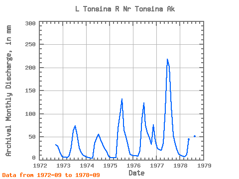
| Point ID: 9218 | Downloads | Plots | Site Data | Code: 15207800 |
| Download | |
|---|---|
| Site Descriptor Information | Site Time Series Data |
| Link to all available data | |

|

|
| View: | Statistics | Time Series |
| Units: | m3/s |
| Statistic | Jan | Feb | Mar | Apr | May | Jun | Jul | Aug | Sep | Oct | Nov | Dec | Annual |
|---|---|---|---|---|---|---|---|---|---|---|---|---|---|
| Mean | 10.67 | 8.75 | 8.49 | 14.34 | 64.33 | 102.08 | 104.51 | 66.52 | 38.71 | 29.80 | 26.41 | 15.12 | 515.65 |
| Standard Deviation | 7.63 | 6.21 | 6.39 | 12.13 | 32.90 | 62.92 | 57.27 | 26.97 | 11.33 | 8.24 | 24.92 | 13.35 | 244.38 |
| Min | 4.94 | 4.69 | 4.08 | 3.95 | 28.33 | 46.77 | 57.52 | 44.80 | 26.26 | 16.10 | 9.87 | 8.24 | 290.88 |
| Max | 25.59 | 21.02 | 21.18 | 36.24 | 113.00 | 217.53 | 207.64 | 119.48 | 53.09 | 39.44 | 76.27 | 42.10 | 887.25 |
| Coefficient of Variation | 0.71 | 0.71 | 0.75 | 0.85 | 0.51 | 0.62 | 0.55 | 0.41 | 0.29 | 0.28 | 0.94 | 0.88 | 0.47 |
| Year | Jan | Feb | Mar | Apr | May | Jun | Jul | Aug | Sep | Oct | Nov | Dec | Annual | 1972 | 32.38 | 30.16 | 18.05 | 8.25 | 1973 | 6.47 | 5.89 | 5.15 | 9.40 | 28.33 | 63.15 | 75.79 | 54.83 | 26.26 | 16.10 | 9.87 | 8.24 | 308.03 | 1974 | 6.47 | 4.69 | 4.08 | 3.95 | 37.61 | 46.77 | 57.52 | 44.80 | 33.96 | 25.17 | 18.97 | 8.33 | 290.88 | 1975 | 4.94 | 4.69 | 5.15 | 5.28 | 70.55 | 98.23 | 135.95 | 66.56 | 50.51 | 32.83 | 11.86 | 11.00 | 494.49 | 1976 | 9.96 | 8.55 | 8.15 | 19.93 | 90.19 | 122.78 | 77.65 | 60.66 | 47.47 | 35.07 | 76.27 | 42.10 | 597.58 | 1977 | 25.59 | 21.02 | 21.18 | 36.24 | 113.00 | 217.53 | 207.64 | 119.48 | 53.09 | 39.44 | 23.43 | 12.81 | 887.25 | 1978 | 10.62 | 7.68 | 7.25 | 11.23 | 46.30 | 64.04 | 72.51 | 52.80 | 27.30 |
|---|
 Return to R-Arctic Net Home Page