|
|
|||||||||||||||||
| Point ID: 9218 | Downloads | Plots | Site Data | Code: 15207800 |
|
|
|||||||||||||||||
| Download | |
|---|---|
| Site Descriptor Information | Site Time Series Data |
| Link to all available data | |
| View: | Time Series | All |
| Units: | mm |
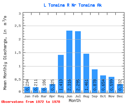
| Statistic | Jan | Feb | Mar | Apr | May | Jun | Jul | Aug | Sep | Oct | Nov | Dec | Annual |
|---|---|---|---|---|---|---|---|---|---|---|---|---|---|
| Mean | 0.23 | 0.21 | 0.19 | 0.33 | 1.41 | 2.32 | 2.29 | 1.46 | 0.88 | 0.65 | 0.60 | 0.33 | 0.96 |
| Standard Deviation | 0.17 | 0.15 | 0.14 | 0.28 | 0.72 | 1.43 | 1.26 | 0.59 | 0.26 | 0.18 | 0.56 | 0.29 | 0.46 |
| Min | 0.11 | 0.11 | 0.09 | 0.09 | 0.62 | 1.06 | 1.26 | 0.98 | 0.60 | 0.35 | 0.22 | 0.18 | 0.54 |
| Max | 0.56 | 0.51 | 0.47 | 0.82 | 2.48 | 4.94 | 4.56 | 2.62 | 1.20 | 0.87 | 1.73 | 0.92 | 1.65 |
| Coefficient of Variation | 0.71 | 0.71 | 0.75 | 0.85 | 0.51 | 0.62 | 0.55 | 0.41 | 0.29 | 0.28 | 0.94 | 0.88 | 0.47 |
 Return to R-Arctic Net Home Page