|
|
|||||||||||||||||
| Point ID: 9204 | Downloads | Plots | Site Data | Code: 15238600 |
|
|
|||||||||||||||||
| Download | |
|---|---|
| Site Descriptor Information | Site Time Series Data |
| Link to all available data | |
| View: | Time Series | All |
| Units: | m3/s |
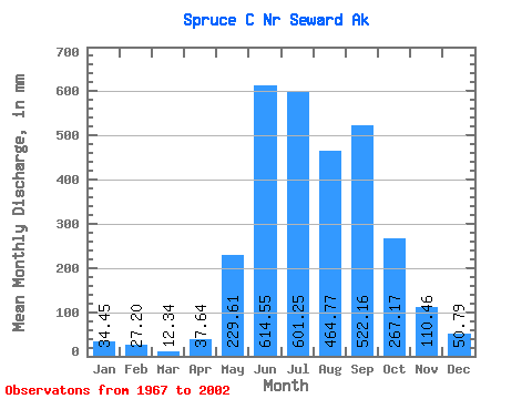
| Statistic | Jan | Feb | Mar | Apr | May | Jun | Jul | Aug | Sep | Oct | Nov | Dec | Annual |
|---|---|---|---|---|---|---|---|---|---|---|---|---|---|
| Mean | 34.49 | 27.45 | 12.32 | 37.60 | 229.58 | 614.59 | 601.17 | 464.71 | 522.19 | 267.17 | 110.48 | 50.75 | 2931.24 |
| Standard Deviation | 36.08 | 35.76 | 13.81 | 27.26 | 81.39 | 157.45 | 189.80 | 219.26 | 284.36 | 191.00 | 91.95 | 42.63 | 677.89 |
| Min | 2.02 | 0.00 | 0.00 | 0.35 | 96.22 | 352.37 | 327.25 | 178.94 | 148.63 | 53.47 | 28.64 | 11.09 | 1652.81 |
| Max | 145.04 | 133.58 | 48.09 | 108.33 | 424.49 | 968.07 | 1167.65 | 1015.52 | 1134.35 | 1046.30 | 392.88 | 160.88 | 4192.60 |
| Coefficient of Variation | 1.05 | 1.30 | 1.12 | 0.72 | 0.35 | 0.26 | 0.32 | 0.47 | 0.55 | 0.71 | 0.83 | 0.84 | 0.23 |
 Return to R-Arctic Net Home Page