|
|
|||||||||||||||||
| Point ID: 9204 | Downloads | Plots | Site Data | Code: 15238600 |
|
|
|||||||||||||||||
| Download | |
|---|---|
| Site Descriptor Information | Site Time Series Data |
| Link to all available data | |
|
|
| View: | Statistics | Time Series |
| Units: | m3/s |
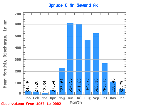
| Statistic | Jan | Feb | Mar | Apr | May | Jun | Jul | Aug | Sep | Oct | Nov | Dec | Annual |
|---|---|---|---|---|---|---|---|---|---|---|---|---|---|
| Mean | 34.49 | 27.45 | 12.32 | 37.60 | 229.58 | 614.59 | 601.17 | 464.71 | 522.19 | 267.17 | 110.48 | 50.75 | 2931.24 |
| Standard Deviation | 36.08 | 35.76 | 13.81 | 27.26 | 81.39 | 157.45 | 189.80 | 219.26 | 284.36 | 191.00 | 91.95 | 42.63 | 677.89 |
| Min | 2.02 | 0.00 | 0.00 | 0.35 | 96.22 | 352.37 | 327.25 | 178.94 | 148.63 | 53.47 | 28.64 | 11.09 | 1652.81 |
| Max | 145.04 | 133.58 | 48.09 | 108.33 | 424.49 | 968.07 | 1167.65 | 1015.52 | 1134.35 | 1046.30 | 392.88 | 160.88 | 4192.60 |
| Coefficient of Variation | 1.05 | 1.30 | 1.12 | 0.72 | 0.35 | 0.26 | 0.32 | 0.47 | 0.55 | 0.71 | 0.83 | 0.84 | 0.23 |
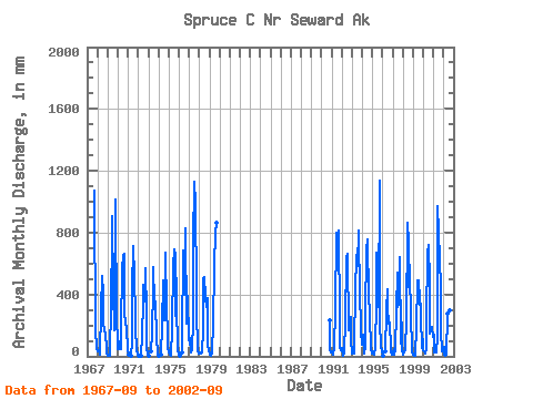
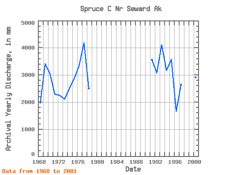
| Year | Jan | Feb | Mar | Apr | May | Jun | Jul | Aug | Sep | Oct | Nov | Dec | Annual | 1967 | 1069.89 | 129.12 | 176.23 | 45.21 | 1968 | 32.07 | 30.21 | 26.88 | 13.72 | 314.90 | 520.48 | 415.03 | 228.29 | 170.15 | 150.03 | 53.71 | 17.06 | 1964.78 | 1969 | 3.63 | 2.83 | 0.60 | 108.33 | 233.04 | 907.26 | 429.70 | 178.94 | 171.17 | 1046.30 | 190.75 | 160.88 | 3417.01 | 1970 | 47.49 | 89.39 | 48.09 | 45.98 | 172.57 | 567.59 | 670.95 | 684.54 | 293.48 | 216.10 | 182.01 | 37.76 | 3045.19 | 1971 | 19.76 | 6.86 | 0.00 | 3.85 | 96.22 | 432.47 | 734.73 | 532.59 | 251.36 | 185.85 | 36.35 | 12.69 | 2295.57 | 1972 | 4.20 | 0.00 | 0.00 | 0.35 | 139.66 | 352.37 | 477.04 | 363.88 | 572.87 | 284.32 | 53.09 | 16.49 | 2255.59 | 1973 | 3.59 | 0.00 | 0.00 | 29.19 | 161.59 | 445.14 | 597.27 | 368.75 | 356.22 | 119.16 | 28.64 | 12.64 | 2112.13 | 1974 | 2.02 | 0.00 | 0.00 | 14.31 | 204.65 | 491.75 | 346.25 | 242.80 | 670.64 | 325.83 | 142.94 | 53.89 | 2493.34 | 1975 | 28.94 | 10.46 | 0.71 | 4.92 | 186.25 | 586.46 | 713.62 | 270.81 | 669.62 | 348.56 | 38.25 | 14.51 | 2864.99 | 1976 | 9.24 | 4.14 | 0.00 | 26.60 | 108.91 | 682.20 | 552.49 | 410.88 | 830.72 | 215.91 | 392.88 | 105.25 | 3342.73 | 1977 | 118.96 | 107.81 | 22.84 | 44.67 | 222.80 | 729.41 | 1167.65 | 1015.52 | 423.22 | 306.54 | 40.91 | 17.16 | 4192.60 | 1978 | 19.29 | 21.25 | 17.94 | 27.13 | 179.15 | 500.89 | 529.93 | 399.31 | 322.41 | 389.67 | 65.07 | 42.33 | 2501.17 | 1979 | 8.64 | 1.07 | 5.62 | 27.61 | 226.24 | 570.94 | 608.16 | 815.68 | 866.87 | 1990 | 242.70 | 41.15 | 26.61 | 1991 | 32.39 | 24.00 | 7.74 | 51.63 | 312.23 | 801.18 | 581.49 | 595.53 | 813.77 | 248.58 | 59.09 | 42.71 | 3564.88 | 1992 | 53.05 | 4.58 | 19.41 | 38.04 | 218.04 | 641.38 | 681.95 | 674.58 | 168.11 | 248.48 | 251.57 | 104.44 | 3084.31 | 1993 | 19.03 | 47.35 | 15.50 | 79.69 | 424.49 | 654.69 | 601.38 | 838.01 | 740.17 | 464.89 | 145.38 | 96.12 | 4110.07 | 1994 | 77.29 | 133.58 | 20.83 | 61.44 | 274.36 | 685.14 | 780.62 | 386.32 | 397.54 | 280.97 | 48.63 | 16.85 | 3158.57 | 1995 | 36.02 | 31.40 | 12.99 | 62.53 | 362.87 | 670.11 | 610.50 | 326.02 | 1134.35 | 219.34 | 70.85 | 30.27 | 3569.51 | 1996 | 13.52 | 0.30 | 0.00 | 32.02 | 308.88 | 435.42 | 331.25 | 218.43 | 219.99 | 53.47 | 34.68 | 11.09 | 1652.81 | 1997 | 27.83 | 45.26 | 9.08 | 41.84 | 307.46 | 542.51 | 327.25 | 343.18 | 638.74 | 86.79 | 217.96 | 46.69 | 2638.65 | 1998 | 13.52 | 31.91 | 42.23 | 85.88 | 209.91 | 864.52 | 762.95 | 466.00 | 590.84 | 210.93 | 104.67 | 29.78 | 3408.69 | 1999 | 9.80 | 1.02 | 1.15 | 18.95 | 185.44 | 488.60 | 505.26 | 346.33 | 430.02 | 272.64 | 51.09 | 112.23 | 2411.45 | 2000 | 40.55 | 28.90 | 15.61 | 46.80 | 242.09 | 670.63 | 744.62 | 491.37 | 148.63 | 191.84 | 190.65 | 126.07 | 2922.30 | 2001 | 145.04 | 24.83 | 26.89 | 27.49 | 134.09 | 968.07 | 823.62 | 649.20 | 445.46 | 174.17 | 35.09 | 39.29 | 3481.08 | 2002 | 61.96 | 11.55 | 1.48 | 9.46 | 284.01 | 540.99 | 434.26 | 306.13 | 658.55 |
|---|
 Return to R-Arctic Net Home Page