|
|
|||||||||||||||||
| Point ID: 9204 | Downloads | Plots | Site Data | Code: 15238600 |
|
|
|||||||||||||||||
| Download | |
|---|---|
| Site Descriptor Information | Site Time Series Data |
| Link to all available data | |
| View: | Time Series | All |
| Units: | mm |
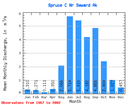
| Statistic | Jan | Feb | Mar | Apr | May | Jun | Jul | Aug | Sep | Oct | Nov | Dec | Annual |
|---|---|---|---|---|---|---|---|---|---|---|---|---|---|
| Mean | 0.31 | 0.27 | 0.11 | 0.35 | 2.07 | 5.71 | 5.41 | 4.18 | 4.86 | 2.40 | 1.03 | 0.46 | 2.24 |
| Standard Deviation | 0.33 | 0.35 | 0.12 | 0.25 | 0.73 | 1.46 | 1.71 | 1.97 | 2.64 | 1.72 | 0.85 | 0.38 | 0.52 |
| Min | 0.02 | 0.00 | 0.00 | 0.00 | 0.87 | 3.28 | 2.94 | 1.61 | 1.38 | 0.48 | 0.27 | 0.10 | 1.26 |
| Max | 1.30 | 1.32 | 0.43 | 1.01 | 3.82 | 9.00 | 10.51 | 9.14 | 10.55 | 9.42 | 3.65 | 1.45 | 3.20 |
| Coefficient of Variation | 1.05 | 1.30 | 1.12 | 0.72 | 0.35 | 0.26 | 0.32 | 0.47 | 0.55 | 0.71 | 0.83 | 0.84 | 0.23 |
 Return to R-Arctic Net Home Page