|
|
|||||||||||||||||
| Point ID: 9166 | Downloads | Plots | Site Data | Code: 15086600 |
|
|
|||||||||||||||||
| Download | |
|---|---|
| Site Descriptor Information | Site Time Series Data |
| Link to all available data | |
| View: | Time Series | All |
| Units: | m3/s |
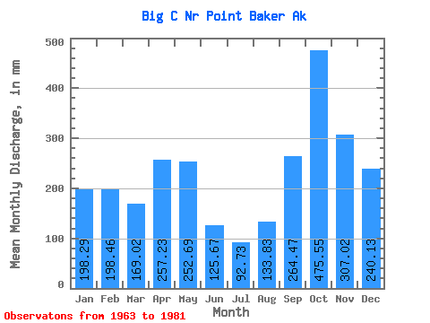
| Statistic | Jan | Feb | Mar | Apr | May | Jun | Jul | Aug | Sep | Oct | Nov | Dec | Annual |
|---|---|---|---|---|---|---|---|---|---|---|---|---|---|
| Mean | 198.25 | 200.20 | 169.03 | 257.22 | 252.65 | 125.64 | 92.75 | 133.85 | 264.43 | 475.46 | 307.05 | 240.07 | 2710.34 |
| Standard Deviation | 141.19 | 111.70 | 58.72 | 63.29 | 120.73 | 52.68 | 43.99 | 62.55 | 132.63 | 171.12 | 167.33 | 113.52 | 316.54 |
| Min | 18.35 | 16.40 | 56.17 | 134.49 | 53.06 | 18.10 | 25.21 | 16.31 | 20.28 | 259.46 | 82.77 | 89.66 | 2274.10 |
| Max | 488.14 | 410.87 | 268.24 | 347.75 | 490.01 | 248.87 | 165.02 | 220.58 | 507.12 | 872.21 | 789.74 | 429.19 | 3439.72 |
| Coefficient of Variation | 0.71 | 0.56 | 0.35 | 0.25 | 0.48 | 0.42 | 0.47 | 0.47 | 0.50 | 0.36 | 0.55 | 0.47 | 0.12 |
 Return to R-Arctic Net Home Page