|
|
|||||||||||||||||
| Point ID: 9166 | Downloads | Plots | Site Data | Code: 15086600 |
|
|
|||||||||||||||||
| Download | |
|---|---|
| Site Descriptor Information | Site Time Series Data |
| Link to all available data | |
| View: | Time Series | All |
| Units: | mm |
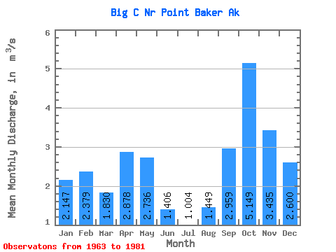
| Statistic | Jan | Feb | Mar | Apr | May | Jun | Jul | Aug | Sep | Oct | Nov | Dec | Annual |
|---|---|---|---|---|---|---|---|---|---|---|---|---|---|
| Mean | 2.15 | 2.38 | 1.83 | 2.88 | 2.74 | 1.41 | 1.00 | 1.45 | 2.96 | 5.15 | 3.44 | 2.60 | 2.49 |
| Standard Deviation | 1.53 | 1.33 | 0.64 | 0.71 | 1.31 | 0.59 | 0.48 | 0.68 | 1.48 | 1.85 | 1.87 | 1.23 | 0.29 |
| Min | 0.20 | 0.20 | 0.61 | 1.50 | 0.57 | 0.20 | 0.27 | 0.18 | 0.23 | 2.81 | 0.93 | 0.97 | 2.09 |
| Max | 5.29 | 4.88 | 2.91 | 3.89 | 5.31 | 2.78 | 1.79 | 2.39 | 5.67 | 9.45 | 8.84 | 4.65 | 3.16 |
| Coefficient of Variation | 0.71 | 0.56 | 0.35 | 0.25 | 0.48 | 0.42 | 0.47 | 0.47 | 0.50 | 0.36 | 0.55 | 0.47 | 0.12 |
 Return to R-Arctic Net Home Page