|
|
|||||||||||||||||
| Point ID: 9166 | Downloads | Plots | Site Data | Code: 15086600 |
|
|
|||||||||||||||||
| Download | |
|---|---|
| Site Descriptor Information | Site Time Series Data |
| Link to all available data | |
|
|
| View: | Statistics | Time Series |
| Units: | m3/s |
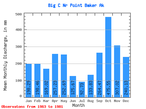
| Statistic | Jan | Feb | Mar | Apr | May | Jun | Jul | Aug | Sep | Oct | Nov | Dec | Annual |
|---|---|---|---|---|---|---|---|---|---|---|---|---|---|
| Mean | 198.25 | 200.20 | 169.03 | 257.22 | 252.65 | 125.64 | 92.75 | 133.85 | 264.43 | 475.46 | 307.05 | 240.07 | 2710.34 |
| Standard Deviation | 141.19 | 111.70 | 58.72 | 63.29 | 120.73 | 52.68 | 43.99 | 62.55 | 132.63 | 171.12 | 167.33 | 113.52 | 316.54 |
| Min | 18.35 | 16.40 | 56.17 | 134.49 | 53.06 | 18.10 | 25.21 | 16.31 | 20.28 | 259.46 | 82.77 | 89.66 | 2274.10 |
| Max | 488.14 | 410.87 | 268.24 | 347.75 | 490.01 | 248.87 | 165.02 | 220.58 | 507.12 | 872.21 | 789.74 | 429.19 | 3439.72 |
| Coefficient of Variation | 0.71 | 0.56 | 0.35 | 0.25 | 0.48 | 0.42 | 0.47 | 0.47 | 0.50 | 0.36 | 0.55 | 0.47 | 0.12 |
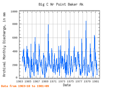
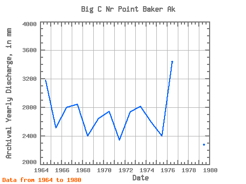
| Year | Jan | Feb | Mar | Apr | May | Jun | Jul | Aug | Sep | Oct | Nov | Dec | Annual | 1963 | 332.77 | 243.22 | 429.19 | 1964 | 346.01 | 410.87 | 187.01 | 317.04 | 220.07 | 148.24 | 102.59 | 179.76 | 154.40 | 491.86 | 377.45 | 228.43 | 3178.86 | 1965 | 441.07 | 212.81 | 162.30 | 313.75 | 274.56 | 108.50 | 25.21 | 16.31 | 20.28 | 523.32 | 126.12 | 296.17 | 2514.13 | 1966 | 102.66 | 97.01 | 202.62 | 203.16 | 389.70 | 92.80 | 37.77 | 138.25 | 476.40 | 623.37 | 206.44 | 239.64 | 2800.62 | 1967 | 244.53 | 265.31 | 105.35 | 153.46 | 280.72 | 54.72 | 145.91 | 179.68 | 507.12 | 412.06 | 253.09 | 233.23 | 2841.36 | 1968 | 205.07 | 160.38 | 268.24 | 276.38 | 123.42 | 105.70 | 73.14 | 60.05 | 373.74 | 321.72 | 335.44 | 90.51 | 2401.79 | 1969 | 20.93 | 16.40 | 121.72 | 307.76 | 166.26 | 93.13 | 154.96 | 220.58 | 179.43 | 259.46 | 789.74 | 317.76 | 2646.88 | 1970 | 176.71 | 346.57 | 242.26 | 196.57 | 209.53 | 165.78 | 150.15 | 218.31 | 441.23 | 365.92 | 117.36 | 100.22 | 2744.87 | 1971 | 124.84 | 196.14 | 88.91 | 252.34 | 378.40 | 158.85 | 63.90 | 176.12 | 206.61 | 277.69 | 296.55 | 114.05 | 2341.14 | 1972 | 101.73 | 95.22 | 221.34 | 134.49 | 490.01 | 248.87 | 45.53 | 216.12 | 239.09 | 498.86 | 302.27 | 156.81 | 2740.27 | 1973 | 267.57 | 311.26 | 182.38 | 328.10 | 291.69 | 137.94 | 145.35 | 165.35 | 249.73 | 412.90 | 82.77 | 237.45 | 2817.89 | 1974 | 18.35 | 226.51 | 56.17 | 347.75 | 330.42 | 120.48 | 82.65 | 52.69 | 178.18 | 728.88 | 219.35 | 229.01 | 2593.93 | 1975 | 143.49 | 43.21 | 94.90 | 324.13 | 337.32 | 158.43 | 110.26 | 97.61 | 150.34 | 273.56 | 273.26 | 401.35 | 2398.34 | 1976 | 488.14 | 239.40 | 183.21 | 309.53 | 318.68 | 101.73 | 165.02 | 149.81 | 317.29 | 379.08 | 384.78 | 405.56 | 3439.72 | 1977 | 212.31 | 336.02 | 180.93 | 212.76 | 53.06 | 136.47 | 62.61 | 44.87 | 125.93 | 600.50 | 344.04 | 89.66 | 2415.06 | 1978 | 123.47 | 178.69 | 194.77 | 226.52 | 326.11 | 205.60 | 50.51 | 155.72 | 290.81 | 872.21 | 334.09 | 113.79 | 3068.76 | 1979 | 42.51 | 44.67 | 161.88 | 207.36 | 202.27 | 103.86 | 97.98 | 89.92 | 192.10 | 526.61 | 249.88 | 367.19 | 2274.10 | 1980 | 113.97 | 177.78 | 247.74 | 252.16 | 93.49 | 18.10 | 67.50 | 115.15 | 250.14 | 657.60 | 591.14 | 271.19 | 2857.99 | 1981 | 395.19 | 245.40 | 140.79 | 266.77 | 62.07 | 102.34 | 88.47 | 133.01 | 406.98 |
|---|
 Return to R-Arctic Net Home Page