|
|
|||||||||||||||||
| Point ID: 9161 | Downloads | Plots | Site Data | Code: 15129000 |
|
|
|||||||||||||||||
| Download | |
|---|---|
| Site Descriptor Information | Site Time Series Data |
| Link to all available data | |
| View: | Time Series | All |
| Units: | m3/s |
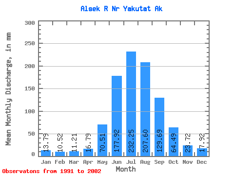
| Statistic | Jan | Feb | Mar | Apr | May | Jun | Jul | Aug | Sep | Oct | Nov | Dec | Annual |
|---|---|---|---|---|---|---|---|---|---|---|---|---|---|
| Mean | 13.79 | 10.61 | 11.21 | 16.79 | 70.50 | 177.92 | 232.22 | 207.57 | 129.69 | 64.48 | 23.72 | 17.92 | 971.18 |
| Standard Deviation | 5.12 | 3.36 | 3.20 | 4.89 | 21.13 | 18.78 | 22.73 | 30.48 | 38.98 | 27.93 | 7.10 | 7.21 | 133.99 |
| Min | 8.24 | 6.67 | 8.21 | 11.47 | 45.37 | 140.10 | 198.91 | 161.70 | 76.07 | 32.57 | 15.26 | 8.74 | 737.62 |
| Max | 24.67 | 16.33 | 17.91 | 28.47 | 108.52 | 219.93 | 266.78 | 268.89 | 199.93 | 109.06 | 37.01 | 33.75 | 1224.31 |
| Coefficient of Variation | 0.37 | 0.32 | 0.28 | 0.29 | 0.30 | 0.11 | 0.10 | 0.15 | 0.30 | 0.43 | 0.30 | 0.40 | 0.14 |
 Return to R-Arctic Net Home Page