|
|
|||||||||||||||||
| Point ID: 9161 | Downloads | Plots | Site Data | Code: 15129000 |
|
|
|||||||||||||||||
| Download | |
|---|---|
| Site Descriptor Information | Site Time Series Data |
| Link to all available data | |
| View: | Time Series | All |
| Units: | mm |
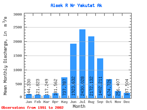
| Statistic | Jan | Feb | Mar | Apr | May | Jun | Jul | Aug | Sep | Oct | Nov | Dec | Annual |
|---|---|---|---|---|---|---|---|---|---|---|---|---|---|
| Mean | 144.33 | 121.82 | 117.25 | 181.56 | 737.79 | 1923.63 | 2430.03 | 2172.13 | 1402.21 | 674.73 | 256.41 | 187.50 | 862.36 |
| Standard Deviation | 53.52 | 38.63 | 33.47 | 52.88 | 221.07 | 203.09 | 237.84 | 319.00 | 421.46 | 292.27 | 76.73 | 75.45 | 118.98 |
| Min | 86.23 | 76.66 | 85.89 | 124.01 | 474.81 | 1514.76 | 2081.47 | 1692.07 | 822.42 | 340.86 | 165.02 | 91.44 | 654.97 |
| Max | 258.19 | 187.60 | 187.44 | 307.80 | 1135.60 | 2377.77 | 2791.68 | 2813.78 | 2161.52 | 1141.26 | 400.12 | 353.14 | 1087.13 |
| Coefficient of Variation | 0.37 | 0.32 | 0.28 | 0.29 | 0.30 | 0.11 | 0.10 | 0.15 | 0.30 | 0.43 | 0.30 | 0.40 | 0.14 |
 Return to R-Arctic Net Home Page