|
|
|||||||||||||||||
| Point ID: 9161 | Downloads | Plots | Site Data | Code: 15129000 |
|
|
|||||||||||||||||
| Download | |
|---|---|
| Site Descriptor Information | Site Time Series Data |
| Link to all available data | |
|
|
| View: | Statistics | Time Series |
| Units: | m3/s |
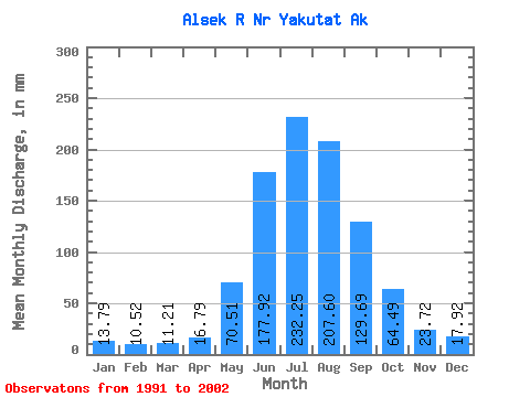
| Statistic | Jan | Feb | Mar | Apr | May | Jun | Jul | Aug | Sep | Oct | Nov | Dec | Annual |
|---|---|---|---|---|---|---|---|---|---|---|---|---|---|
| Mean | 13.79 | 10.61 | 11.21 | 16.79 | 70.50 | 177.92 | 232.22 | 207.57 | 129.69 | 64.48 | 23.72 | 17.92 | 971.18 |
| Standard Deviation | 5.12 | 3.36 | 3.20 | 4.89 | 21.13 | 18.78 | 22.73 | 30.48 | 38.98 | 27.93 | 7.10 | 7.21 | 133.99 |
| Min | 8.24 | 6.67 | 8.21 | 11.47 | 45.37 | 140.10 | 198.91 | 161.70 | 76.07 | 32.57 | 15.26 | 8.74 | 737.62 |
| Max | 24.67 | 16.33 | 17.91 | 28.47 | 108.52 | 219.93 | 266.78 | 268.89 | 199.93 | 109.06 | 37.01 | 33.75 | 1224.31 |
| Coefficient of Variation | 0.37 | 0.32 | 0.28 | 0.29 | 0.30 | 0.11 | 0.10 | 0.15 | 0.30 | 0.43 | 0.30 | 0.40 | 0.14 |
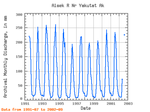
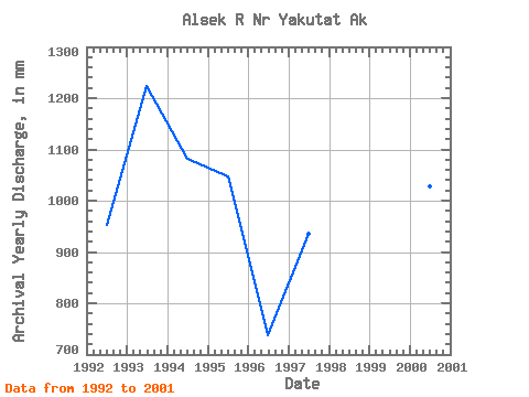
| Year | Jan | Feb | Mar | Apr | May | Jun | Jul | Aug | Sep | Oct | Nov | Dec | Annual | 1991 | 228.74 | 221.02 | 165.80 | 65.83 | 18.62 | 15.88 | 1992 | 12.46 | 14.54 | 17.91 | 28.47 | 91.52 | 177.86 | 260.79 | 203.88 | 76.07 | 38.49 | 20.00 | 16.87 | 952.92 | 1993 | 15.16 | 16.33 | 13.11 | 13.36 | 108.52 | 219.93 | 266.78 | 232.28 | 181.65 | 108.42 | 33.65 | 20.99 | 1224.31 | 1994 | 11.68 | 7.26 | 11.52 | 16.48 | 63.58 | 178.59 | 235.10 | 268.89 | 154.69 | 109.06 | 20.56 | 11.74 | 1082.39 | 1995 | 8.24 | 6.67 | 8.21 | 20.41 | 100.77 | 188.37 | 252.46 | 189.04 | 199.93 | 49.20 | 15.96 | 13.99 | 1048.85 | 1996 | 10.57 | 8.26 | 8.76 | 13.91 | 45.68 | 140.10 | 198.91 | 161.70 | 96.98 | 32.57 | 15.26 | 8.74 | 737.62 | 1997 | 8.38 | 8.28 | 8.25 | 16.28 | 65.53 | 180.34 | 224.56 | 225.58 | 122.70 | 33.33 | 22.82 | 24.46 | 935.59 | 1998 | 14.26 | 12.90 | 12.93 | 21.37 | 61.10 | 175.33 | 203.39 | 169.99 | 91.77 | 68.04 | 23.58 | 12.17 | 862.71 | 1999 | 13.37 | 7.04 | 8.26 | 13.86 | 63.46 | 166.91 | 211.41 | 179.37 | 104.55 | 57.34 | 30.47 | 33.75 | 884.79 | 2000 | 21.46 | 11.77 | 10.56 | 13.72 | 56.61 | 174.56 | 249.99 | 202.08 | 140.69 | 92.94 | 37.01 | 23.58 | 1029.47 | 2001 | 24.67 | 13.40 | 14.78 | 15.40 | 45.37 | 183.86 | 242.14 | 204.26 | 121.96 | 54.03 | 22.96 | 14.95 | 953.12 | 2002 | 11.44 | 10.23 | 8.96 | 11.47 | 73.40 | 171.29 | 212.35 | 232.80 | 99.54 |
|---|
 Return to R-Arctic Net Home Page