|
|
|||||||||||||||||
| Point ID: 8857 | Downloads | Plots | Site Data | Code: 70321 |
|
|
|||||||||||||||||
| Download | |
|---|---|
| Site Descriptor Information | Site Time Series Data |
| Link to all available data | |
| View: | Time Series | All |
| Units: | m3/s |
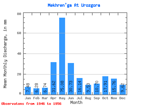
| Statistic | Jan | Feb | Mar | Apr | May | Jun | Jul | Aug | Sep | Oct | Nov | Dec | Annual |
|---|---|---|---|---|---|---|---|---|---|---|---|---|---|
| Mean | 7.48 | 6.34 | 6.74 | 31.62 | 75.06 | 30.73 | 16.14 | 9.53 | 10.70 | 17.91 | 15.76 | 9.62 | 244.02 |
| Standard Deviation | 1.30 | 0.78 | 0.62 | 22.21 | 28.37 | 16.11 | 10.35 | 1.22 | 5.16 | 7.28 | 7.96 | 3.18 | 23.09 |
| Min | 5.57 | 4.90 | 5.57 | 7.29 | 30.23 | 13.68 | 9.32 | 8.21 | 7.53 | 9.01 | 8.00 | 5.79 | 206.22 |
| Max | 10.37 | 8.10 | 7.90 | 71.67 | 123.41 | 66.29 | 44.18 | 12.40 | 24.73 | 30.67 | 34.52 | 16.78 | 275.42 |
| Coefficient of Variation | 0.17 | 0.12 | 0.09 | 0.70 | 0.38 | 0.52 | 0.64 | 0.13 | 0.48 | 0.41 | 0.51 | 0.33 | 0.10 |
 Return to R-Arctic Net Home Page