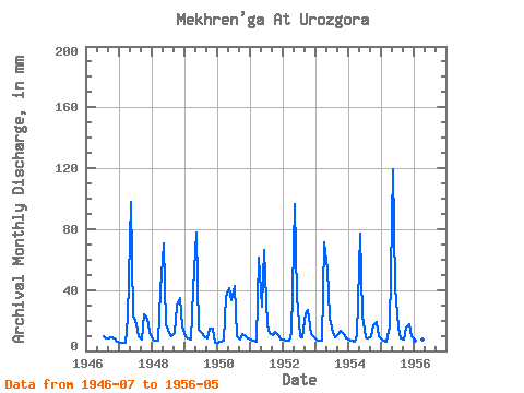
| Point ID: 8857 | Downloads | Plots | Site Data | Code: 70321 |
| Download | |
|---|---|
| Site Descriptor Information | Site Time Series Data |
| Link to all available data | |

|

|
| View: | Statistics | Time Series |
| Units: | m3/s |
| Statistic | Jan | Feb | Mar | Apr | May | Jun | Jul | Aug | Sep | Oct | Nov | Dec | Annual |
|---|---|---|---|---|---|---|---|---|---|---|---|---|---|
| Mean | 7.48 | 6.34 | 6.74 | 31.62 | 75.06 | 30.73 | 16.14 | 9.53 | 10.70 | 17.91 | 15.76 | 9.62 | 244.02 |
| Standard Deviation | 1.30 | 0.78 | 0.62 | 22.21 | 28.37 | 16.11 | 10.35 | 1.22 | 5.16 | 7.28 | 7.96 | 3.18 | 23.09 |
| Min | 5.57 | 4.90 | 5.57 | 7.29 | 30.23 | 13.68 | 9.32 | 8.21 | 7.53 | 9.01 | 8.00 | 5.79 | 206.22 |
| Max | 10.37 | 8.10 | 7.90 | 71.67 | 123.41 | 66.29 | 44.18 | 12.40 | 24.73 | 30.67 | 34.52 | 16.78 | 275.42 |
| Coefficient of Variation | 0.17 | 0.12 | 0.09 | 0.70 | 0.38 | 0.52 | 0.64 | 0.13 | 0.48 | 0.41 | 0.51 | 0.33 | 0.10 |
| Year | Jan | Feb | Mar | Apr | May | Jun | Jul | Aug | Sep | Oct | Nov | Dec | Annual | 1946 | 10.00 | 8.33 | 8.12 | 9.01 | 8.00 | 6.42 | 1947 | 5.57 | 4.90 | 5.57 | 21.74 | 101.20 | 23.05 | 18.27 | 9.75 | 7.70 | 24.74 | 21.08 | 12.71 | 254.55 | 1948 | 7.78 | 6.35 | 6.85 | 39.95 | 72.81 | 17.92 | 12.22 | 9.87 | 12.06 | 30.67 | 34.52 | 16.78 | 267.00 | 1949 | 10.37 | 8.10 | 7.90 | 40.55 | 80.22 | 13.68 | 12.03 | 9.69 | 8.36 | 14.87 | 14.99 | 5.79 | 225.79 | 1950 | 5.80 | 6.02 | 7.28 | 35.36 | 42.58 | 33.38 | 44.18 | 9.87 | 7.53 | 11.79 | 9.38 | 8.21 | 220.76 | 1951 | 7.71 | 6.52 | 6.60 | 61.52 | 30.23 | 66.29 | 17.15 | 12.40 | 10.09 | 13.02 | 10.33 | 8.02 | 250.88 | 1952 | 7.78 | 6.52 | 7.03 | 11.82 | 99.96 | 35.30 | 9.63 | 9.32 | 24.73 | 27.71 | 11.05 | 9.69 | 259.18 | 1953 | 7.65 | 6.13 | 6.79 | 71.67 | 55.23 | 21.80 | 12.40 | 9.56 | 10.99 | 13.82 | 11.29 | 8.89 | 236.34 | 1954 | 7.47 | 6.46 | 6.66 | 10.33 | 79.60 | 22.99 | 9.32 | 8.27 | 9.50 | 17.65 | 19.29 | 9.75 | 206.22 | 1955 | 7.47 | 6.18 | 6.23 | 15.95 | 123.41 | 42.16 | 16.17 | 8.21 | 7.88 | 15.80 | 17.68 | 9.94 | 275.42 | 1956 | 7.22 | 6.18 | 6.48 | 7.29 | 65.41 |
|---|
 Return to R-Arctic Net Home Page