|
|
|||||||||||||||||
| Point ID: 8857 | Downloads | Plots | Site Data | Code: 70321 |
|
|
|||||||||||||||||
| Download | |
|---|---|
| Site Descriptor Information | Site Time Series Data |
| Link to all available data | |
| View: | Time Series | All |
| Units: | mm |
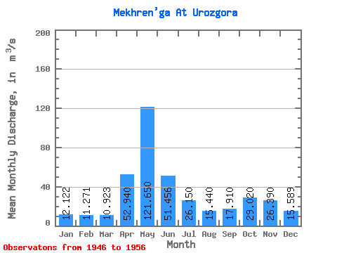
| Statistic | Jan | Feb | Mar | Apr | May | Jun | Jul | Aug | Sep | Oct | Nov | Dec | Annual |
|---|---|---|---|---|---|---|---|---|---|---|---|---|---|
| Mean | 12.12 | 11.27 | 10.92 | 52.94 | 121.65 | 51.46 | 26.15 | 15.44 | 17.91 | 29.02 | 26.39 | 15.59 | 33.56 |
| Standard Deviation | 2.10 | 1.38 | 1.00 | 37.20 | 45.98 | 26.98 | 16.78 | 1.98 | 8.64 | 11.79 | 13.32 | 5.15 | 3.17 |
| Min | 9.02 | 8.71 | 9.03 | 12.20 | 49.00 | 22.90 | 15.10 | 13.30 | 12.60 | 14.60 | 13.40 | 9.39 | 28.36 |
| Max | 16.80 | 14.40 | 12.80 | 120.00 | 200.00 | 111.00 | 71.60 | 20.10 | 41.40 | 49.70 | 57.80 | 27.20 | 37.88 |
| Coefficient of Variation | 0.17 | 0.12 | 0.09 | 0.70 | 0.38 | 0.52 | 0.64 | 0.13 | 0.48 | 0.41 | 0.51 | 0.33 | 0.10 |
 Return to R-Arctic Net Home Page