|
|
|||||||||||||||||
| Point ID: 885 | Downloads | Plots | Site Data | Code: 07FB006 |
|
|
|||||||||||||||||
| Download | |
|---|---|
| Site Descriptor Information | Site Time Series Data |
| Link to all available data | |
| View: | Time Series | All |
| Units: | m3/s |
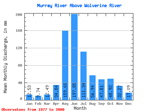
| Statistic | Jan | Feb | Mar | Apr | May | Jun | Jul | Aug | Sep | Oct | Nov | Dec | Annual |
|---|---|---|---|---|---|---|---|---|---|---|---|---|---|
| Mean | 12.53 | 9.82 | 12.48 | 34.84 | 159.63 | 197.85 | 111.33 | 56.93 | 47.81 | 48.92 | 32.27 | 17.09 | 739.12 |
| Standard Deviation | 3.57 | 3.13 | 5.42 | 18.09 | 43.40 | 61.55 | 36.09 | 15.99 | 26.29 | 23.61 | 16.00 | 5.89 | 118.53 |
| Min | 6.75 | 5.92 | 6.04 | 12.15 | 81.45 | 68.08 | 55.45 | 27.00 | 21.08 | 20.22 | 11.51 | 7.68 | 462.02 |
| Max | 22.67 | 21.77 | 27.22 | 84.00 | 266.69 | 333.41 | 205.57 | 92.78 | 104.33 | 108.34 | 82.71 | 34.89 | 1026.97 |
| Coefficient of Variation | 0.28 | 0.32 | 0.43 | 0.52 | 0.27 | 0.31 | 0.32 | 0.28 | 0.55 | 0.48 | 0.50 | 0.34 | 0.16 |
 Return to R-Arctic Net Home Page