|
|
|||||||||||||||||
| Point ID: 885 | Downloads | Plots | Site Data | Code: 07FB006 |
|
|
|||||||||||||||||
| Download | |
|---|---|
| Site Descriptor Information | Site Time Series Data |
| Link to all available data | |
|
|
| View: | Statistics | Time Series |
| Units: | m3/s |
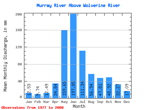
| Statistic | Jan | Feb | Mar | Apr | May | Jun | Jul | Aug | Sep | Oct | Nov | Dec | Annual |
|---|---|---|---|---|---|---|---|---|---|---|---|---|---|
| Mean | 12.53 | 9.82 | 12.48 | 34.84 | 159.63 | 197.85 | 111.33 | 56.93 | 47.81 | 48.92 | 32.27 | 17.09 | 739.12 |
| Standard Deviation | 3.57 | 3.13 | 5.42 | 18.09 | 43.40 | 61.55 | 36.09 | 15.99 | 26.29 | 23.61 | 16.00 | 5.89 | 118.53 |
| Min | 6.75 | 5.92 | 6.04 | 12.15 | 81.45 | 68.08 | 55.45 | 27.00 | 21.08 | 20.22 | 11.51 | 7.68 | 462.02 |
| Max | 22.67 | 21.77 | 27.22 | 84.00 | 266.69 | 333.41 | 205.57 | 92.78 | 104.33 | 108.34 | 82.71 | 34.89 | 1026.97 |
| Coefficient of Variation | 0.28 | 0.32 | 0.43 | 0.52 | 0.27 | 0.31 | 0.32 | 0.28 | 0.55 | 0.48 | 0.50 | 0.34 | 0.16 |
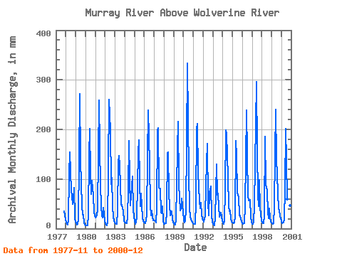
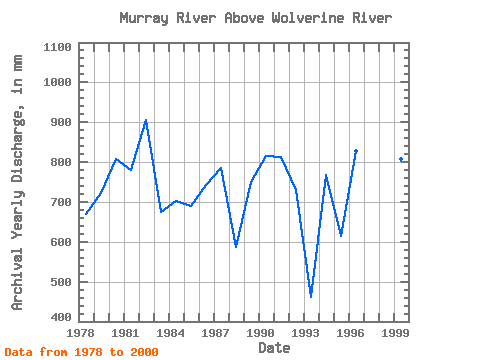
| Year | Jan | Feb | Mar | Apr | May | Jun | Jul | Aug | Sep | Oct | Nov | Dec | Annual | 1977 | 35.81 | 18.56 | 1978 | 12.67 | 8.64 | 8.33 | 18.50 | 112.23 | 153.80 | 78.67 | 66.78 | 49.90 | 59.78 | 82.71 | 20.67 | 671.39 | 1979 | 10.88 | 7.31 | 10.08 | 19.90 | 137.79 | 272.11 | 141.12 | 48.56 | 28.29 | 29.11 | 11.51 | 7.68 | 722.86 | 1980 | 6.75 | 5.92 | 6.04 | 27.64 | 152.24 | 201.12 | 113.34 | 71.89 | 97.23 | 68.67 | 32.80 | 27.56 | 808.93 | 1981 | 22.67 | 21.77 | 27.22 | 37.64 | 266.69 | 162.40 | 91.45 | 46.23 | 24.41 | 22.89 | 42.59 | 17.56 | 780.27 | 1982 | 9.85 | 7.51 | 7.16 | 12.15 | 123.34 | 260.28 | 205.57 | 92.78 | 103.14 | 45.34 | 25.60 | 16.00 | 906.23 | 1983 | 11.78 | 8.93 | 9.76 | 36.35 | 138.90 | 147.35 | 131.12 | 50.34 | 48.61 | 42.23 | 36.78 | 15.11 | 674.74 | 1984 | 12.22 | 11.04 | 11.33 | 24.31 | 81.45 | 176.38 | 99.67 | 48.67 | 67.00 | 108.34 | 38.18 | 24.89 | 701.91 | 1985 | 15.34 | 9.29 | 12.00 | 23.12 | 157.79 | 178.54 | 96.34 | 46.45 | 70.88 | 47.89 | 21.19 | 13.11 | 690.00 | 1986 | 13.11 | 10.53 | 17.11 | 28.18 | 146.68 | 238.76 | 135.57 | 48.67 | 26.46 | 37.34 | 23.98 | 17.45 | 741.86 | 1987 | 17.34 | 13.77 | 12.11 | 41.30 | 204.46 | 203.27 | 85.67 | 84.12 | 32.48 | 31.89 | 45.71 | 16.11 | 785.94 | 1988 | 10.19 | 8.72 | 10.60 | 35.81 | 157.79 | 153.80 | 71.34 | 47.56 | 26.35 | 35.89 | 18.07 | 13.00 | 587.02 | 1989 | 10.62 | 7.90 | 7.54 | 18.39 | 163.35 | 216.18 | 90.90 | 64.00 | 36.89 | 41.12 | 61.41 | 34.89 | 751.30 | 1990 | 17.56 | 10.93 | 15.78 | 38.93 | 176.68 | 333.41 | 111.12 | 43.78 | 21.62 | 20.22 | 14.95 | 12.00 | 816.72 | 1991 | 9.40 | 8.63 | 10.30 | 53.24 | 206.68 | 210.80 | 115.56 | 58.89 | 41.19 | 54.00 | 26.89 | 21.45 | 814.04 | 1992 | 17.11 | 12.25 | 26.67 | 84.00 | 136.68 | 171.01 | 55.45 | 27.00 | 72.92 | 87.78 | 27.86 | 12.89 | 731.27 | 1993 | 8.90 | 6.92 | 7.26 | 22.80 | 133.34 | 68.08 | 73.12 | 45.23 | 23.66 | 27.22 | 31.94 | 16.45 | 462.02 | 1994 | 10.82 | 8.15 | 17.56 | 77.11 | 205.57 | 190.37 | 108.68 | 44.67 | 35.28 | 38.11 | 19.36 | 13.89 | 767.05 | 1995 | 12.00 | 10.33 | 12.78 | 23.12 | 183.35 | 147.35 | 74.78 | 65.67 | 27.10 | 27.45 | 19.14 | 15.34 | 615.38 | 1996 | 10.62 | 9.07 | 10.78 | 45.92 | 140.01 | 238.76 | 154.46 | 67.45 | 56.47 | 60.12 | 23.12 | 13.00 | 827.65 | 1997 | 10.19 | 9.30 | 12.45 | 47.00 | 217.80 | 295.77 | 161.12 | 71.78 | 45.39 | 100.79 | 42.48 | 16.45 | 1026.97 | 1998 | 12.33 | 10.33 | 11.45 | 26.57 | 192.24 | 90.13 | 78.78 | 33.11 | 21.08 | 41.89 | 21.51 | 13.67 | 549.35 | 1999 | 10.49 | 9.15 | 10.61 | 41.84 | 153.35 | 239.84 | 145.57 | 74.67 | 39.04 | 39.23 | 23.98 | 21.78 | 807.15 | 2000 | 15.34 | 9.46 | 12.22 | 17.53 | 83.01 | 201.12 | 141.12 | 61.12 | 104.33 | 57.78 | 46.78 | 10.61 | 759.74 |
|---|
 Return to R-Arctic Net Home Page