|
|
|||||||||||||||||
| Point ID: 885 | Downloads | Plots | Site Data | Code: 07FB006 |
|
|
|||||||||||||||||
| Download | |
|---|---|
| Site Descriptor Information | Site Time Series Data |
| Link to all available data | |
| View: | Time Series | All |
| Units: | mm |
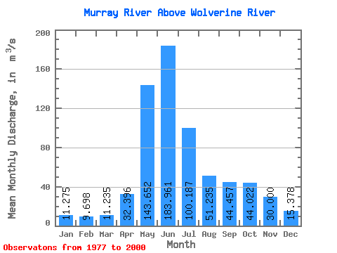
| Statistic | Jan | Feb | Mar | Apr | May | Jun | Jul | Aug | Sep | Oct | Nov | Dec | Annual |
|---|---|---|---|---|---|---|---|---|---|---|---|---|---|
| Mean | 11.28 | 9.70 | 11.23 | 32.40 | 143.65 | 183.96 | 100.19 | 51.23 | 44.46 | 44.02 | 30.00 | 15.38 | 56.44 |
| Standard Deviation | 3.22 | 3.10 | 4.88 | 16.82 | 39.05 | 57.23 | 32.48 | 14.39 | 24.44 | 21.25 | 14.88 | 5.30 | 9.05 |
| Min | 6.07 | 5.85 | 5.44 | 11.30 | 73.30 | 63.30 | 49.90 | 24.30 | 19.60 | 18.20 | 10.70 | 6.91 | 35.28 |
| Max | 20.40 | 21.50 | 24.50 | 78.10 | 240.00 | 310.00 | 185.00 | 83.50 | 97.00 | 97.50 | 76.90 | 31.40 | 78.42 |
| Coefficient of Variation | 0.28 | 0.32 | 0.43 | 0.52 | 0.27 | 0.31 | 0.32 | 0.28 | 0.55 | 0.48 | 0.50 | 0.34 | 0.16 |
 Return to R-Arctic Net Home Page