|
|
|||||||||||||||||
| Point ID: 880 | Downloads | Plots | Site Data | Code: 07FB001 |
|
|
|||||||||||||||||
| Download | |
|---|---|
| Site Descriptor Information | Site Time Series Data |
| Link to all available data | |
| View: | Time Series | All |
| Units: | m3/s |
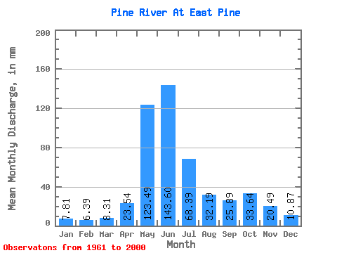
| Statistic | Jan | Feb | Mar | Apr | May | Jun | Jul | Aug | Sep | Oct | Nov | Dec | Annual |
|---|---|---|---|---|---|---|---|---|---|---|---|---|---|
| Mean | 7.81 | 6.44 | 8.31 | 23.54 | 123.47 | 143.60 | 68.38 | 32.19 | 25.89 | 33.63 | 20.49 | 10.87 | 495.32 |
| Standard Deviation | 2.00 | 2.23 | 4.05 | 12.58 | 30.31 | 51.82 | 29.93 | 21.09 | 14.20 | 15.59 | 8.58 | 4.29 | 95.56 |
| Min | 4.01 | 3.47 | 3.50 | 6.77 | 59.76 | 41.77 | 27.89 | 11.80 | 9.06 | 12.15 | 10.56 | 5.62 | 315.99 |
| Max | 12.42 | 13.13 | 24.79 | 64.48 | 178.16 | 280.62 | 140.54 | 110.00 | 83.33 | 71.04 | 47.13 | 32.31 | 704.32 |
| Coefficient of Variation | 0.26 | 0.35 | 0.49 | 0.53 | 0.24 | 0.36 | 0.44 | 0.66 | 0.55 | 0.46 | 0.42 | 0.40 | 0.19 |
 Return to R-Arctic Net Home Page