|
|
|||||||||||||||||
| Point ID: 880 | Downloads | Plots | Site Data | Code: 07FB001 |
|
|
|||||||||||||||||
| Download | |
|---|---|
| Site Descriptor Information | Site Time Series Data |
| Link to all available data | |
|
|
| View: | Statistics | Time Series |
| Units: | m3/s |
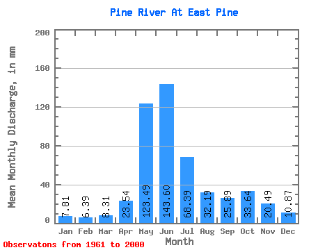
| Statistic | Jan | Feb | Mar | Apr | May | Jun | Jul | Aug | Sep | Oct | Nov | Dec | Annual |
|---|---|---|---|---|---|---|---|---|---|---|---|---|---|
| Mean | 7.81 | 6.44 | 8.31 | 23.54 | 123.47 | 143.60 | 68.38 | 32.19 | 25.89 | 33.63 | 20.49 | 10.87 | 495.32 |
| Standard Deviation | 2.00 | 2.23 | 4.05 | 12.58 | 30.31 | 51.82 | 29.93 | 21.09 | 14.20 | 15.59 | 8.58 | 4.29 | 95.56 |
| Min | 4.01 | 3.47 | 3.50 | 6.77 | 59.76 | 41.77 | 27.89 | 11.80 | 9.06 | 12.15 | 10.56 | 5.62 | 315.99 |
| Max | 12.42 | 13.13 | 24.79 | 64.48 | 178.16 | 280.62 | 140.54 | 110.00 | 83.33 | 71.04 | 47.13 | 32.31 | 704.32 |
| Coefficient of Variation | 0.26 | 0.35 | 0.49 | 0.53 | 0.24 | 0.36 | 0.44 | 0.66 | 0.55 | 0.46 | 0.42 | 0.40 | 0.19 |
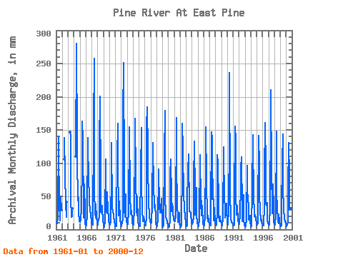
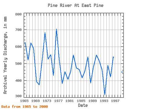
| Year | Jan | Feb | Mar | Apr | May | Jun | Jul | Aug | Sep | Oct | Nov | Dec | Annual | 1961 | 11.02 | 10.04 | 9.41 | 18.21 | 143.42 | 118.25 | 42.49 | 14.36 | 27.63 | 50.02 | 29.35 | 1962 | 109.56 | 138.17 | 86.09 | 40.72 | 18.96 | 42.72 | 1963 | 151.38 | 140.10 | 49.80 | 19.43 | 19.69 | 32.53 | 1964 | 113.98 | 280.62 | 131.91 | 110.00 | 43.06 | 48.91 | 25.28 | 12.75 | 1965 | 12.08 | 13.13 | 15.23 | 32.13 | 102.69 | 163.23 | 140.54 | 25.89 | 18.12 | 70.82 | 24.64 | 8.59 | 624.88 | 1966 | 6.99 | 5.50 | 5.62 | 22.71 | 142.53 | 118.25 | 87.86 | 41.17 | 29.13 | 29.66 | 23.56 | 11.53 | 521.96 | 1967 | 8.99 | 6.80 | 7.04 | 8.91 | 158.02 | 257.06 | 62.19 | 25.01 | 17.87 | 39.40 | 18.04 | 12.70 | 621.35 | 1968 | 7.17 | 9.32 | 14.72 | 18.64 | 132.57 | 200.93 | 73.26 | 27.44 | 25.06 | 37.62 | 31.70 | 13.57 | 591.29 | 1969 | 7.64 | 3.99 | 3.83 | 13.07 | 109.11 | 84.40 | 27.89 | 24.57 | 56.55 | 28.77 | 20.09 | 13.17 | 392.09 | 1970 | 8.37 | 6.39 | 6.73 | 12.10 | 88.53 | 130.24 | 36.08 | 26.56 | 22.71 | 20.07 | 11.89 | 5.62 | 374.94 | 1971 | 5.36 | 4.96 | 5.20 | 16.62 | 113.10 | 159.38 | 108.67 | 21.16 | 26.35 | 43.60 | 14.31 | 9.63 | 526.39 | 1972 | 6.42 | 4.19 | 11.75 | 13.97 | 175.07 | 250.63 | 82.55 | 30.54 | 18.46 | 54.45 | 22.71 | 13.99 | 682.82 | 1973 | 8.79 | 7.48 | 11.11 | 26.56 | 159.57 | 154.24 | 55.99 | 23.68 | 29.35 | 28.99 | 14.18 | 9.21 | 527.70 | 1974 | 7.35 | 7.00 | 8.85 | 31.49 | 127.92 | 166.87 | 82.78 | 28.11 | 20.54 | 52.01 | 11.80 | 8.39 | 551.39 | 1975 | 7.30 | 5.10 | 4.89 | 8.87 | 89.64 | 152.95 | 75.25 | 25.01 | 17.35 | 13.21 | 18.83 | 13.35 | 430.95 | 1976 | 8.56 | 5.69 | 5.71 | 18.98 | 160.68 | 184.87 | 122.61 | 107.12 | 33.85 | 28.77 | 18.74 | 12.53 | 704.32 | 1977 | 9.72 | 10.43 | 11.07 | 37.70 | 135.23 | 119.75 | 72.37 | 33.64 | 33.85 | 38.73 | 18.12 | 8.17 | 527.11 | 1978 | 6.68 | 5.06 | 5.27 | 15.81 | 83.22 | 90.40 | 35.85 | 25.67 | 25.49 | 30.10 | 47.13 | 12.28 | 382.42 | 1979 | 6.49 | 3.81 | 6.37 | 15.74 | 115.53 | 178.87 | 55.99 | 18.44 | 15.36 | 17.75 | 11.05 | 6.37 | 451.25 | 1980 | 4.01 | 3.47 | 3.50 | 15.19 | 85.65 | 106.04 | 50.90 | 28.33 | 39.20 | 32.09 | 25.06 | 14.72 | 407.21 | 1981 | 12.42 | 11.76 | 14.21 | 21.38 | 174.40 | 100.89 | 37.62 | 20.72 | 11.48 | 15.07 | 25.71 | 9.89 | 453.71 | 1982 | 5.31 | 4.09 | 3.85 | 6.77 | 96.50 | 159.16 | 126.60 | 49.35 | 36.84 | 32.53 | 20.39 | 10.42 | 549.61 | 1983 | 6.11 | 4.94 | 5.82 | 24.85 | 104.24 | 94.68 | 117.74 | 27.89 | 26.99 | 27.89 | 24.42 | 10.22 | 473.31 | 1984 | 8.76 | 8.65 | 10.31 | 19.19 | 74.59 | 133.03 | 53.12 | 23.02 | 39.20 | 64.85 | 21.64 | 10.22 | 465.99 | 1985 | 7.44 | 5.04 | 6.26 | 14.27 | 113.10 | 112.89 | 41.61 | 21.91 | 43.27 | 29.44 | 13.88 | 7.95 | 416.06 | 1986 | 7.26 | 5.83 | 10.11 | 18.16 | 110.00 | 154.24 | 75.47 | 20.63 | 11.91 | 21.25 | 12.34 | 9.38 | 455.36 | 1987 | 10.27 | 8.11 | 6.55 | 26.99 | 151.38 | 137.10 | 47.58 | 78.79 | 16.71 | 14.34 | 32.35 | 10.69 | 538.89 | 1988 | 6.62 | 6.01 | 7.72 | 27.42 | 115.97 | 100.68 | 37.62 | 22.57 | 12.70 | 20.32 | 15.92 | 13.12 | 385.44 | 1989 | 9.91 | 6.74 | 6.49 | 16.54 | 128.59 | 117.60 | 45.59 | 36.52 | 17.65 | 22.80 | 38.77 | 32.31 | 477.77 | 1990 | 11.42 | 6.53 | 9.49 | 29.56 | 141.87 | 235.64 | 55.55 | 18.50 | 10.18 | 12.15 | 10.71 | 9.38 | 551.06 | 1991 | 6.51 | 5.89 | 6.95 | 44.34 | 160.90 | 134.74 | 53.56 | 23.24 | 21.64 | 37.62 | 13.15 | 11.07 | 517.83 | 1992 | 9.76 | 7.80 | 24.79 | 64.48 | 94.50 | 109.25 | 28.77 | 13.28 | 34.06 | 53.78 | 15.34 | 6.31 | 461.86 | 1993 | 4.56 | 4.36 | 5.18 | 15.21 | 99.82 | 41.77 | 53.78 | 30.98 | 14.50 | 16.91 | 21.04 | 10.16 | 315.99 | 1994 | 6.13 | 4.56 | 8.76 | 56.34 | 146.96 | 124.67 | 57.10 | 20.45 | 18.34 | 22.80 | 15.45 | 9.67 | 489.85 | 1995 | 7.75 | 6.82 | 9.27 | 22.06 | 146.29 | 94.68 | 54.00 | 30.32 | 13.64 | 19.50 | 10.56 | 9.03 | 421.58 | 1996 | 6.84 | 5.49 | 6.11 | 35.77 | 87.64 | 160.66 | 96.28 | 40.95 | 36.20 | 41.61 | 13.28 | 8.99 | 538.67 | 1997 | 7.21 | 6.98 | 8.85 | 34.06 | 178.16 | 209.93 | 87.64 | 36.08 | 23.99 | 71.04 | 31.49 | 10.67 | 703.88 | 1998 | 7.99 | 6.45 | 7.13 | 21.64 | 152.49 | 52.48 | 36.30 | 11.80 | 9.06 | 23.46 | 12.30 | 7.72 | 346.29 | 1999 | 5.73 | 4.96 | 5.98 | 33.20 | 104.24 | 143.74 | 66.62 | 31.21 | 15.25 | 16.09 | 11.59 | 11.57 | 449.23 | 2000 | 8.17 | 5.02 | 7.24 | 12.06 | 59.76 | 131.10 | 81.67 | 32.53 | 83.33 | 41.61 | 31.92 | 6.84 | 501.16 |
|---|
 Return to R-Arctic Net Home Page