|
|
|||||||||||||||||
| Point ID: 880 | Downloads | Plots | Site Data | Code: 07FB001 |
|
|
|||||||||||||||||
| Download | |
|---|---|
| Site Descriptor Information | Site Time Series Data |
| Link to all available data | |
| View: | Time Series | All |
| Units: | mm |
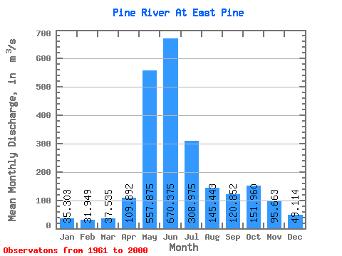
| Statistic | Jan | Feb | Mar | Apr | May | Jun | Jul | Aug | Sep | Oct | Nov | Dec | Annual |
|---|---|---|---|---|---|---|---|---|---|---|---|---|---|
| Mean | 35.30 | 31.95 | 37.53 | 109.89 | 557.88 | 670.38 | 308.98 | 145.44 | 120.85 | 151.96 | 95.66 | 49.11 | 189.91 |
| Standard Deviation | 9.03 | 11.07 | 18.31 | 58.73 | 136.94 | 241.90 | 135.22 | 95.29 | 66.26 | 70.43 | 40.05 | 19.38 | 36.64 |
| Min | 18.10 | 17.20 | 15.80 | 31.60 | 270.00 | 195.00 | 126.00 | 53.30 | 42.30 | 54.90 | 49.30 | 25.40 | 121.15 |
| Max | 56.10 | 65.10 | 112.00 | 301.00 | 805.00 | 1310.00 | 635.00 | 497.00 | 389.00 | 321.00 | 220.00 | 146.00 | 270.03 |
| Coefficient of Variation | 0.26 | 0.35 | 0.49 | 0.53 | 0.24 | 0.36 | 0.44 | 0.66 | 0.55 | 0.46 | 0.42 | 0.40 | 0.19 |
 Return to R-Arctic Net Home Page