|
|
|||||||||||||||||
| Point ID: 8589 | Downloads | Plots | Site Data | Code: 11177 |
|
|
|||||||||||||||||
| Download | |
|---|---|
| Site Descriptor Information | Site Time Series Data |
| Link to all available data | |
| View: | Time Series | All |
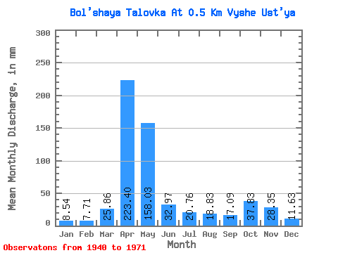
| Units: | m3/s |
| Statistic | Jan | Feb | Mar | Apr | May | Jun | Jul | Aug | Sep | Oct | Nov | Dec | Annual |
|---|---|---|---|---|---|---|---|---|---|---|---|---|---|
| Mean | 8.53 | 7.76 | 25.85 | 223.41 | 158.03 | 32.95 | 20.77 | 18.82 | 17.09 | 37.87 | 28.31 | 11.64 | 611.48 |
| Standard Deviation | 6.27 | 6.02 | 23.16 | 76.05 | 112.99 | 29.92 | 17.76 | 15.74 | 15.72 | 22.77 | 17.20 | 7.97 | 214.45 |
| Min | 3.01 | 2.36 | 3.52 | 128.79 | 16.74 | 5.43 | 3.10 | 3.85 | 4.37 | 6.86 | 7.61 | 4.60 | 326.20 |
| Max | 24.27 | 22.11 | 74.48 | 351.54 | 373.25 | 96.39 | 55.23 | 53.56 | 63.18 | 71.97 | 55.08 | 29.29 | 959.95 |
| Coefficient of Variation | 0.73 | 0.78 | 0.90 | 0.34 | 0.71 | 0.91 | 0.85 | 0.84 | 0.92 | 0.60 | 0.61 | 0.68 | 0.35 |
 Return to R-Arctic Net Home Page