|
|
|||||||||||||||||
| Point ID: 8589 | Downloads | Plots | Site Data | Code: 11177 |
|
|
|||||||||||||||||
| Download | |
|---|---|
| Site Descriptor Information | Site Time Series Data |
| Link to all available data | |
| View: | Time Series | All |
| Units: | mm |
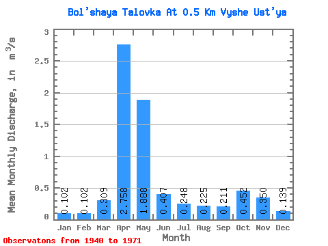
| Statistic | Jan | Feb | Mar | Apr | May | Jun | Jul | Aug | Sep | Oct | Nov | Dec | Annual |
|---|---|---|---|---|---|---|---|---|---|---|---|---|---|
| Mean | 0.10 | 0.10 | 0.31 | 2.76 | 1.89 | 0.41 | 0.25 | 0.23 | 0.21 | 0.45 | 0.35 | 0.14 | 0.62 |
| Standard Deviation | 0.07 | 0.08 | 0.28 | 0.94 | 1.35 | 0.37 | 0.21 | 0.19 | 0.19 | 0.27 | 0.21 | 0.10 | 0.22 |
| Min | 0.04 | 0.03 | 0.04 | 1.59 | 0.20 | 0.07 | 0.04 | 0.05 | 0.05 | 0.08 | 0.09 | 0.06 | 0.33 |
| Max | 0.29 | 0.29 | 0.89 | 4.34 | 4.46 | 1.19 | 0.66 | 0.64 | 0.78 | 0.86 | 0.68 | 0.35 | 0.97 |
| Coefficient of Variation | 0.73 | 0.78 | 0.90 | 0.34 | 0.71 | 0.91 | 0.85 | 0.84 | 0.92 | 0.60 | 0.61 | 0.68 | 0.35 |
 Return to R-Arctic Net Home Page