|
|
|||||||||||||||||
| Point ID: 8589 | Downloads | Plots | Site Data | Code: 11177 |
|
|
|||||||||||||||||
| Download | |
|---|---|
| Site Descriptor Information | Site Time Series Data |
| Link to all available data | |
|
|
| View: | Statistics | Time Series |
| Units: | m3/s |
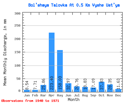
| Statistic | Jan | Feb | Mar | Apr | May | Jun | Jul | Aug | Sep | Oct | Nov | Dec | Annual |
|---|---|---|---|---|---|---|---|---|---|---|---|---|---|
| Mean | 8.53 | 7.76 | 25.85 | 223.41 | 158.03 | 32.95 | 20.77 | 18.82 | 17.09 | 37.87 | 28.31 | 11.64 | 611.48 |
| Standard Deviation | 6.27 | 6.02 | 23.16 | 76.05 | 112.99 | 29.92 | 17.76 | 15.74 | 15.72 | 22.77 | 17.20 | 7.97 | 214.45 |
| Min | 3.01 | 2.36 | 3.52 | 128.79 | 16.74 | 5.43 | 3.10 | 3.85 | 4.37 | 6.86 | 7.61 | 4.60 | 326.20 |
| Max | 24.27 | 22.11 | 74.48 | 351.54 | 373.25 | 96.39 | 55.23 | 53.56 | 63.18 | 71.97 | 55.08 | 29.29 | 959.95 |
| Coefficient of Variation | 0.73 | 0.78 | 0.90 | 0.34 | 0.71 | 0.91 | 0.85 | 0.84 | 0.92 | 0.60 | 0.61 | 0.68 | 0.35 |
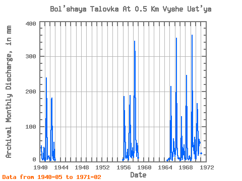
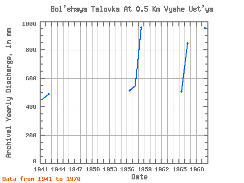
| Year | Jan | Feb | Mar | Apr | May | Jun | Jul | Aug | Sep | Oct | Nov | Dec | Annual | 1940 | 46.87 | 12.15 | 5.69 | 4.77 | 7.70 | 41.84 | 34.83 | 4.60 | 1941 | 3.01 | 2.36 | 7.53 | 238.14 | 127.20 | 12.96 | 6.78 | 9.21 | 14.58 | 17.57 | 7.61 | 6.28 | 454.25 | 1942 | 3.85 | 2.90 | 3.52 | 174.96 | 187.46 | 20.25 | 9.21 | 7.78 | 4.37 | 57.74 | 15.39 | 4.60 | 490.50 | 1956 | 5.86 | 5.03 | 6.11 | 186.30 | 108.79 | 96.39 | 14.23 | 10.04 | 13.77 | 20.09 | 35.64 | 11.72 | 516.05 | 1957 | 8.37 | 4.58 | 29.29 | 136.08 | 194.99 | 19.44 | 14.23 | 53.56 | 11.34 | 22.60 | 38.88 | 17.57 | 548.19 | 1958 | 12.55 | 14.49 | 32.64 | 343.44 | 295.42 | 78.57 | 46.87 | 17.57 | 14.58 | 53.56 | 38.88 | 11.72 | 959.95 | 1964 | 3.85 | 5.02 | 6.86 | 8.91 | 6.53 | 1965 | 6.95 | 7.62 | 20.92 | 213.84 | 48.54 | 5.43 | 3.10 | 25.94 | 30.78 | 66.95 | 48.60 | 29.29 | 509.32 | 1966 | 15.90 | 22.11 | 43.52 | 351.54 | 289.56 | 51.84 | 25.94 | 9.21 | 8.10 | 11.72 | 8.91 | 9.21 | 848.17 | 1967 | 3.85 | 3.81 | 5.27 | 128.79 | 16.74 | 6.88 | 41.84 | 32.64 | 19.44 | 49.38 | 12.15 | 5.44 | 326.20 | 1968 | 6.03 | 6.18 | 74.48 | 245.43 | 71.13 | 8.10 | 7.78 | 4.85 | 7.45 | 15.90 | 16.20 | 9.21 | 473.89 | 1969 | 3.68 | 2.90 | 9.21 | 273.78 | 373.25 | 42.12 | 55.23 | 41.01 | 21.87 | 71.97 | 55.08 | 9.21 | 955.18 | 1970 | 8.03 | 7.40 | 51.89 | 165.24 | 136.41 | 41.31 | 18.41 | 24.27 | 63.18 | 56.07 | 46.98 | 25.94 | 644.60 | 1971 | 24.27 | 13.72 |
|---|
 Return to R-Arctic Net Home Page