|
|
|||||||||||||||||
| Point ID: 854 | Downloads | Plots | Site Data | Code: 07EA002 |
|
|
|||||||||||||||||
| Download | |
|---|---|
| Site Descriptor Information | Site Time Series Data |
| Link to all available data | |
| View: | Time Series | All |
| Units: | m3/s |
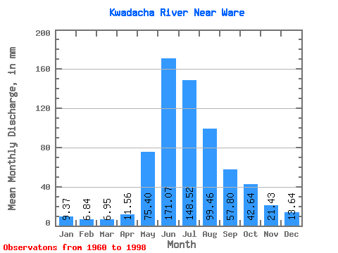
| Statistic | Jan | Feb | Mar | Apr | May | Jun | Jul | Aug | Sep | Oct | Nov | Dec | Annual |
|---|---|---|---|---|---|---|---|---|---|---|---|---|---|
| Mean | 9.37 | 6.90 | 6.95 | 11.56 | 75.39 | 171.07 | 148.50 | 99.45 | 57.80 | 42.63 | 21.43 | 13.64 | 663.04 |
| Standard Deviation | 1.73 | 1.11 | 1.03 | 4.05 | 33.57 | 37.09 | 34.17 | 24.23 | 15.85 | 11.22 | 4.27 | 3.13 | 77.84 |
| Min | 4.45 | 3.10 | 4.73 | 5.91 | 31.89 | 120.46 | 90.12 | 64.67 | 32.48 | 20.67 | 13.01 | 7.56 | 498.69 |
| Max | 12.78 | 9.29 | 9.51 | 23.77 | 148.90 | 252.75 | 222.24 | 161.12 | 103.14 | 70.01 | 29.58 | 19.89 | 793.74 |
| Coefficient of Variation | 0.18 | 0.16 | 0.15 | 0.35 | 0.45 | 0.22 | 0.23 | 0.24 | 0.27 | 0.26 | 0.20 | 0.23 | 0.12 |
 Return to R-Arctic Net Home Page