|
|
|||||||||||||||||
| Point ID: 854 | Downloads | Plots | Site Data | Code: 07EA002 |
|
|
|||||||||||||||||
| Download | |
|---|---|
| Site Descriptor Information | Site Time Series Data |
| Link to all available data | |
|
|
| View: | Statistics | Time Series |
| Units: | m3/s |
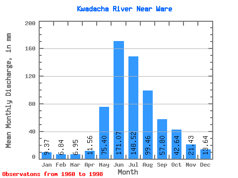
| Statistic | Jan | Feb | Mar | Apr | May | Jun | Jul | Aug | Sep | Oct | Nov | Dec | Annual |
|---|---|---|---|---|---|---|---|---|---|---|---|---|---|
| Mean | 9.37 | 6.90 | 6.95 | 11.56 | 75.39 | 171.07 | 148.50 | 99.45 | 57.80 | 42.63 | 21.43 | 13.64 | 663.04 |
| Standard Deviation | 1.73 | 1.11 | 1.03 | 4.05 | 33.57 | 37.09 | 34.17 | 24.23 | 15.85 | 11.22 | 4.27 | 3.13 | 77.84 |
| Min | 4.45 | 3.10 | 4.73 | 5.91 | 31.89 | 120.46 | 90.12 | 64.67 | 32.48 | 20.67 | 13.01 | 7.56 | 498.69 |
| Max | 12.78 | 9.29 | 9.51 | 23.77 | 148.90 | 252.75 | 222.24 | 161.12 | 103.14 | 70.01 | 29.58 | 19.89 | 793.74 |
| Coefficient of Variation | 0.18 | 0.16 | 0.15 | 0.35 | 0.45 | 0.22 | 0.23 | 0.24 | 0.27 | 0.26 | 0.20 | 0.23 | 0.12 |
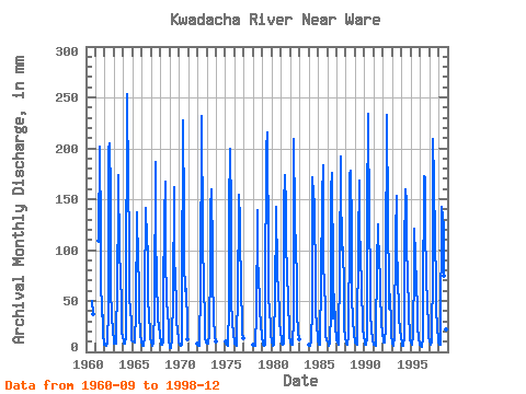
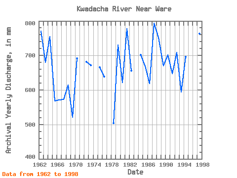
| Year | Jan | Feb | Mar | Apr | May | Jun | Jul | Aug | Sep | Oct | Nov | Dec | Annual | 1960 | 50.44 | 37.78 | 1961 | 112.23 | 201.12 | 117.79 | 77.23 | 35.17 | 36.67 | 18.28 | 7.56 | 1962 | 8.81 | 7.52 | 6.20 | 9.34 | 43.45 | 198.97 | 211.13 | 161.12 | 64.21 | 33.67 | 21.62 | 9.40 | 771.85 | 1963 | 8.81 | 8.03 | 7.99 | 10.26 | 70.12 | 141.97 | 178.90 | 98.90 | 77.55 | 46.45 | 20.65 | 14.34 | 680.62 | 1964 | 11.56 | 7.45 | 8.04 | 15.70 | 46.23 | 252.75 | 166.68 | 116.68 | 47.54 | 48.23 | 24.31 | 11.78 | 755.17 | 1965 | 10.56 | 9.29 | 9.51 | 10.25 | 39.56 | 136.59 | 127.79 | 101.90 | 58.08 | 39.23 | 17.96 | 9.78 | 568.42 | 1966 | 7.52 | 5.99 | 5.80 | 15.27 | 60.23 | 140.89 | 113.34 | 101.12 | 52.05 | 36.23 | 21.19 | 14.22 | 571.63 | 1967 | 9.40 | 6.99 | 6.61 | 7.56 | 44.67 | 186.06 | 126.68 | 64.67 | 45.06 | 32.11 | 26.35 | 17.34 | 572.53 | 1968 | 9.02 | 6.56 | 6.79 | 9.31 | 55.56 | 131.21 | 172.24 | 100.45 | 48.61 | 41.00 | 24.63 | 12.67 | 614.58 | 1969 | 4.45 | 3.10 | 4.73 | 12.26 | 54.67 | 161.33 | 93.67 | 76.89 | 45.39 | 33.00 | 19.79 | 13.67 | 521.66 | 1970 | 8.91 | 6.44 | 6.66 | 6.67 | 50.56 | 226.93 | 136.68 | 91.34 | 59.15 | 63.34 | 24.84 | 12.56 | 692.61 | 1972 | 8.40 | 6.05 | 6.62 | 8.28 | 64.78 | 231.24 | 114.45 | 123.34 | 53.02 | 44.23 | 14.09 | 9.29 | 682.12 | 1973 | 8.74 | 7.64 | 8.95 | 15.06 | 95.01 | 140.89 | 164.46 | 100.34 | 72.28 | 35.45 | 16.02 | 11.04 | 672.46 | 1975 | 10.62 | 7.44 | 6.96 | 5.91 | 47.12 | 139.82 | 205.57 | 141.12 | 47.43 | 31.56 | 16.56 | 10.60 | 666.23 | 1976 | 8.26 | 6.88 | 6.59 | 7.22 | 65.89 | 134.44 | 158.90 | 132.23 | 49.80 | 41.56 | 18.18 | 13.45 | 639.35 | 1978 | 7.53 | 6.32 | 6.27 | 13.34 | 31.89 | 138.74 | 90.12 | 79.90 | 46.78 | 41.67 | 28.18 | 14.56 | 504.24 | 1979 | 9.66 | 6.79 | 6.67 | 6.53 | 53.89 | 198.97 | 222.24 | 93.34 | 51.30 | 44.12 | 23.77 | 16.89 | 730.80 | 1980 | 10.39 | 6.62 | 6.46 | 6.56 | 62.23 | 127.99 | 146.68 | 80.12 | 58.94 | 70.01 | 29.58 | 19.45 | 621.71 | 1981 | 12.56 | 7.88 | 7.39 | 8.00 | 148.90 | 173.16 | 146.68 | 104.90 | 83.57 | 46.12 | 26.14 | 16.78 | 778.27 | 1982 | 9.67 | 6.64 | 6.69 | 7.30 | 33.34 | 208.65 | 135.57 | 100.67 | 76.68 | 40.45 | 18.82 | 12.56 | 656.05 | 1984 | 7.68 | 6.04 | 6.66 | 10.86 | 43.34 | 171.01 | 160.01 | 150.01 | 63.99 | 46.23 | 21.73 | 18.11 | 702.32 | 1985 | 11.11 | 6.77 | 6.87 | 10.08 | 73.78 | 151.65 | 188.91 | 85.56 | 69.16 | 41.00 | 17.10 | 11.11 | 669.77 | 1986 | 10.95 | 7.71 | 6.57 | 7.99 | 42.67 | 158.10 | 181.13 | 78.12 | 32.48 | 58.34 | 22.80 | 15.00 | 618.65 | 1987 | 12.78 | 8.73 | 7.75 | 10.70 | 86.56 | 191.44 | 167.79 | 103.79 | 103.14 | 64.34 | 23.98 | 15.45 | 793.74 | 1988 | 8.80 | 7.40 | 7.57 | 15.38 | 123.34 | 173.16 | 183.35 | 123.34 | 53.99 | 32.00 | 17.85 | 10.61 | 752.43 | 1989 | 8.98 | 7.13 | 7.13 | 17.10 | 110.90 | 167.78 | 117.79 | 105.56 | 55.28 | 35.89 | 22.91 | 16.45 | 670.09 | 1990 | 9.45 | 6.11 | 7.71 | 14.30 | 140.01 | 233.39 | 128.90 | 78.23 | 40.76 | 20.67 | 13.77 | 11.33 | 702.43 | 1991 | 7.69 | 6.86 | 5.59 | 13.66 | 92.45 | 120.46 | 128.90 | 85.45 | 79.59 | 61.01 | 28.82 | 19.89 | 647.27 | 1992 | 12.11 | 8.19 | 9.30 | 23.77 | 82.90 | 232.31 | 133.34 | 65.45 | 42.16 | 58.23 | 24.95 | 17.67 | 708.97 | 1993 | 7.78 | 5.85 | 6.07 | 15.49 | 117.79 | 152.72 | 105.90 | 76.12 | 40.22 | 32.56 | 22.69 | 13.67 | 594.25 | 1994 | 10.30 | 5.89 | 6.21 | 14.63 | 101.90 | 159.18 | 152.24 | 100.56 | 81.31 | 36.56 | 18.93 | 12.56 | 697.20 | 1995 | 9.62 | 7.36 | 7.06 | 16.45 | 86.56 | 120.46 | 96.67 | 65.78 | 44.20 | 24.78 | 13.01 | 8.66 | 498.69 | 1996 | 6.81 | 5.51 | 5.53 | 13.87 | 47.23 | 172.08 | 176.68 | 127.79 | 74.10 | 48.56 | 24.74 | 15.45 | 715.28 | 1997 | 10.13 | 8.03 | 7.21 | 9.49 | 86.90 | 208.65 | 172.24 | 112.23 | 69.59 | 45.56 | 21.94 | 14.56 | 763.64 | 1998 | 10.20 | 6.49 | 7.09 | 12.80 | 146.68 | 132.29 | 125.57 | 77.01 | 49.80 | 43.67 | 22.37 | 15.34 | 645.35 |
|---|
 Return to R-Arctic Net Home Page